From the city that celebrates the sinking of a ship ( Portsmouth celebrates the raising of a ship ).
Should the location of this file change please use the keyword "divdev7" in
a search engine to find it again.
A number of the pictures are now apparently not downloadable, because the hosts have disallowed
remote linking although not saying so. To view them , you have to remove the picture file name
from the picture URL and put this .htm file name in its place
and scroll down to the relevant pic.
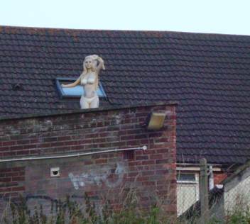
On Weston
foreshore,one letter to each paving stone so the only way to view the whole
script was from one of the tall blocks on International Way. It read
something like: LOOK OUT BEYOND YOU AND SEE THE SHIT THAT YOU HAVE CREATED
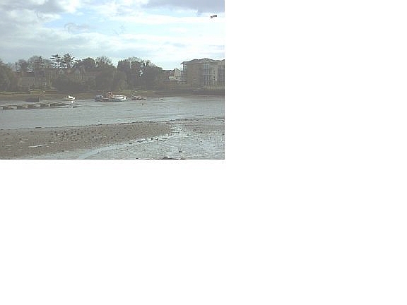
The vista on the other side of Southampton Water consists of Fawley refinery
and the associated Hythe chemical works.
On the footpath alongside the
railway between the Civic Centre and the Central Railway Station a long time ago
BAN THE CALL-UP DJ and JT
On the end of a terrace of run down
housing in Eastgate St in the late 60s IF THE LUFTWAFFE DOESN'T GET YOU THE
COUNCIL WILL DJ
In the 1980's the City Council in their infinite
wisdom had a road safety car sticker made which read 'SLOW DOWN, THIS IS
SOUTHAMPTON'. Most I knew took it as a sign that any radical change was
still a long way off. - RM
My favourite was 1970s on the wall of the underpass
between Bellvue Rd and St Mary's Road. A slight vestige of this remained till the sites total demise in 2003. In one hand someone had written: BAN BEEFBURGERS and by another hand
underneath: WITH FRAYED EDGES by repute the second part written by the
leading light of the then local listings sheet of that name.
Later on the
same site SPARKY F***S SNAILS AND OTHER MOLLESQUES Exact spelling of molluscs
JT, and spelling confirmed by A.M. There is another curiosity concerning
this area. The pedestrian rampway is flag-stoned. After rain the water collects
under some of these flags. Then if someone unknowingly treads on these flags in
just the wrong place the slab rocks and a jet of water shoots up their
fundament. Sadly no more this subway was filled-in during June 2003.
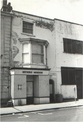
Above a shop window at 59 or 60 Oxford St,Soton a sign used to
be INVISIBLE MENDERS Whenever I went past it I never did in fact see
anyone in there.
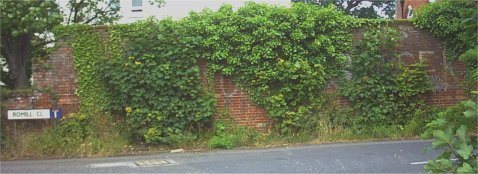
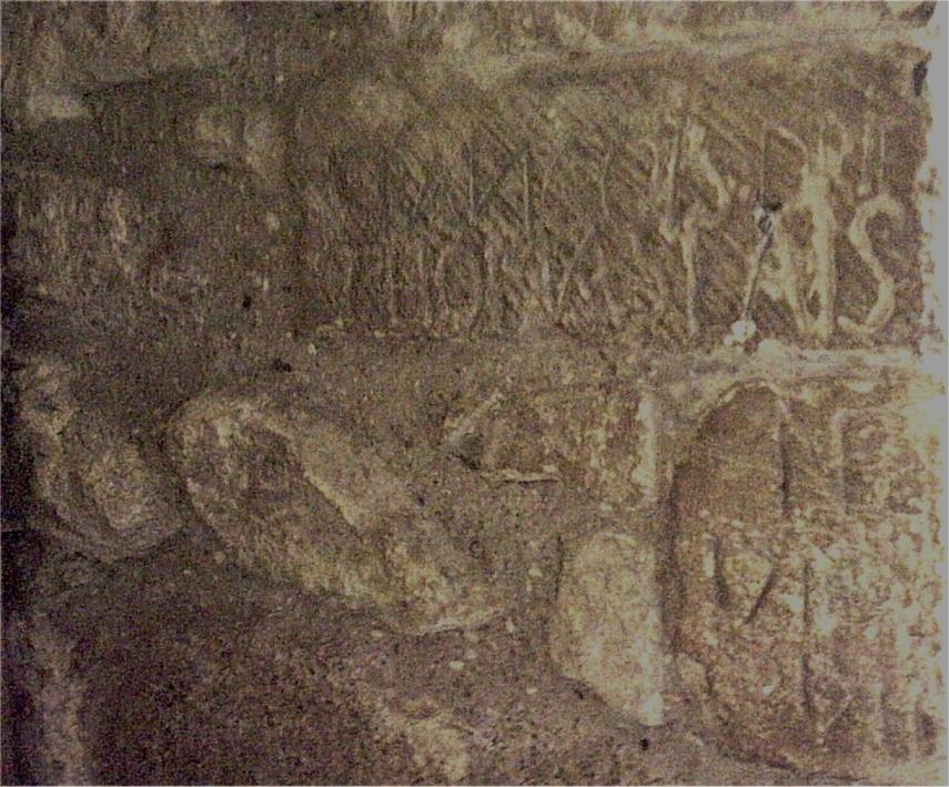
The following remains in place,decades on,partially
overgrown and adulterated. On Mansbridge Rd on the original end of Allington
Lane now called Romill Close near Gaters Mill. It reads , apparently 1968 vintage.
LONG LIVE DUBCEK Acknowledgement to T.W.,I.H, C.M, A.M., A.J. , JT, PJ
,AG and PC
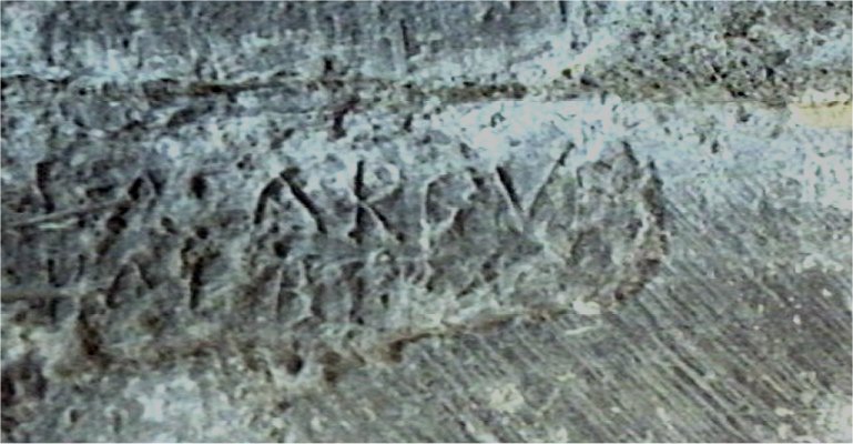
All that is now visible summertime, pictures taken June 2004, is LO.. .... ..BCEK
And a close up of ..BCEK of Dubcek
A
claimant for this "classic" piece of graffiti ? which has the ring of truth
about it from The Echo 18/05/2000 . From a local councillor; when the owners had plans to demolish the
wall as part of a redevelopement this graffiti was another ground for refusal of
planning permission to demolish the wall.
2018 the ivy etc had all been cleared off , leaving the old but still readable script, re-emerging half a century later,
http://www.diverse.4mg.com/dubcek2018.jpg
On the Horseshoe bridge,St
Denys MOONACRE FUZZ IN BELIEF FOR NATURAL ORANGE P.J
Road bridge over main Waterloo bound railway, 2 signs were fixed to
it in September 2008 but neither viewable from the
railway. Reflective bead oval signs with the wording
BML1
EI/209A
77m 20ch
That is 77 miles 20 chains from Waterloo on a year 2008 sign
for the Bournemouth Main Line 1 and bridge number 209A. Also railway
matter in St Denys, the level crossing at adelaide Rd.
This is at a very sharp bend in the tracks , requiring a check rail
to keep the trains from running off the rails. Check rail around
the curve except precisely where you'd think it should be -
at the level crossing. Rails 2.5 inches wide and the gap before the
concrete panel road surface is 3 inches. But the wheel flanges
chip at the concrete , so have the wheels come off the rails
to do this ? http://www.diverse.4mg.com/check_rail1.jpg and http://www.diverse.4mg.com/check_rail2.jpg / BR>
The rails around this area replaced in 2009 and now even less check rail before, 250m radius is now
deemed the limit ,
look out North Road for a derailment. Check rail between the crossing and the station
but not the North Rd section of curve these days, I wonder why? There are now fewer flange activated
grease boxes on this curve. Not only that but either not working or no longer regularly filled with grease
so train wheels squeeling around this tight curve is the norm these days. Previously you could
tell it was a frosty morning because only then would the early morning trains squeel as the
boxes were iced up. The reason for the squeel would seem to be just a function of the curve and fixed axle wheels. So one wheel is forced to
jump and as the weight of the carriage on a curve is thrown outwards, then this skid pattern is the result on the inner curve. A stick-slip repeated skid mark
on the rail almost up to the end of the curve at Priory Rd, repeat
getting wider as the curve gets less , eventually petering out. This
repeated judder must start up resonance of the axle and wheels to
ring like a bell.
Now stand on the up-side of the island platform , platform 2 , when either a fast voyager goes towards
London or a slow but heavy container train. It looks worse , to view in reality , than this video image ,
alarming to see all 3 rails and sleepers bouncing up and down over a length of 10 or so sleepers
Video of main upline track problem
I queried a SWT guard who was waiting at St Denys rail station and he was well aware of the issue.
There is a pump at the side of the track to stop an underground stream flooding this
part of the track, but obviously has caused ground liquifaction or something to the
underlying geology. Whatever they do on the
trackbed , the lack of support soon returns.
Presumably the bright yellow "T" sign by the side of this track 40 yards before the problem area
meaning a local speed restriction in place apparently.
As far as I know the only example of original Southern Rail green paint to be seen these days locally is on one of the ex-signalman houses at where
the Adelaide Rd level crossing, for the then manned signal box, just the
soffit board at the eaves.
Incidently the sign at the Horseshoe Bridge gate for the "Alan Jones Memorial Steps" leading down to
"St Denys Beach" didn't last long. Has anyone else noticed the line of (methane ?) bubbles along
the line of the sheet piling placed parallel to the railway and new path at St Denys Beach? .
I assume they've punctured the peat bed layer mentioned in the Bog Bodies geology
page later on. http://www.geog.port.ac.uk/webmap/itchen/proposal.html, more
locally, has reference to peat underlying the River Itchen.
Subway between
the Central Hall and East St WHY WORRY D.J In this same subway,the
four letters,each drawn out very long so just the four letters covered the
length of the subway. FFFFFFFFUUUUUUUUCCCCCCCCKKKKKKKK Difficult to
describe in a text file T.W
This graffiti appeared over night in many spots in the city. I think the
longest version was Hari and Al Weston 76 and was on the subway wall
between the Royal Oak pub and St Mary's Street and also on one of the
pillars of the old swimming baths where it stayed until their demolition.
there was no context to the graffiti but the fact that it seemed to be
everywhere impressed us. - TN
Some official graffiti at the junction of Banister Rd and Court Rd, September 2007
On a long since demolished co-op building on
the corner of Compton Walk and St Mary's Rd: I WILL HAUNT THESE STATE Don't
ask me ,I've no idea what it means. From DL - "I WILL HAUNT THESE STATE " is
possibly a reference to the same graffiti which I remember from various
locations in London in the mid-70s. The author signed himself as Joseph, always
used white paint and interspersed the "I WILL HAUNT THESE STATE" with
anti-abortion slogans. Also on the same building: PEOPLE BEFORE
PROFIT I.H
On Northam Road railway bridge in one hand: ABORTION A
WOMAN'S RIGHT TO CHOOSE Then in another hand
underneath: SATAN I.H
From JB: I used to live on Northam Rd and I'm sure the graffiti on the bridge when it appeared read ..."A WOMENS RIGHT TO CHOOSE" - obviously an English student !
I'm sure I'll revisit the site for nostalgic reasons again.
BUY ONE, GET ONE FREE
Large orange sign in the window of the Shoe Zone shop , 201 Portswood Road
Assuming the following is a succinct analysis
of the public perceptions of 4 letter words I have dropped my usual policy of
asterisking. This one was from the mid 1980's. On a building in St Mary
Street
FUCK THE POPE Next day someone with some sensitivity had blanked
out the offending word so that it now read FUCK THE **** G
Seeing the head knocked off the statue of Margaret Thatcher recently
reminded me of the following. In East Park there is a statue to Richard Andrews
1798-1859 who many years ago suffered the indignity of having his nose knocked
off by someone. (Whoever repaired his nose did a good job of concealing the join
but could have etched it to pockmark to match the remaining 1.5 centuries of
acid rain .) To add to the indignity someone obviously took it upon themselves
to climb up and place a litter bin over his head ,perhaps 20 feet off the
ground,so it looked more of a statue of Ned Kelly. Whenever the parkies removed
the bin ,the next night it would return again.
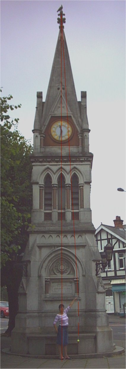
Concerning another Southampton monument: The Leaning Tower of Bitterne
Triangle, the Bitterne Park Triangle clocktower. August 2002 I crudely (no theodolite so accuracy only to plus or
minus an inch) surveyed the tilt. Using a plumbob ,by sighting, the tilt towards
the river was 2 foot 1 inches out of vertical. The string of the bob sighted
down the middle of the brown marble pillar and measurement scaled to represent
intercept at ground level. In the picture the overlaid red line from the
yellow plumb-bob is extented to the top-knot with seagull and compare to the
overlaid centre-line. The shod feet of my beautiful assistant are 10.5 inches long.
Picture taken 17 July 2004. Lean measured in April 2005 was 1 foot 11 inches.
Lean measured on 10 Sept 2005 it it has lurched to 2 foot 4 inches, 12 Nov 2005 2 foot 3 inches,
Feb 18,2006 lurched towards the river by now 2 ft 6 inches, in the drought
on 20 July 2006, 2 foot 3 inches. A nice still morning ,
5 November, 2006 and the lean is now 2 foot 7 inches.
That was with extra
care in measuring. Near windless day, long stick as a steady and a small
bucket to protect the plum-bob from any wind. An indepenent measurement by
an estate agent surveyor with an improvised plumbob,
on 30 June 2007, determined the lean to be 660mm (2 foot 2 inches ).
30 March, 2008 lean increased to 2 foot 7 inches.
15 March , 2009, 2 foot 2 inches
Ah well some way to go before
that line is near to passing outside the base, let alone the centre of
gravity passing outside the base.
Incidently near this area , in the foreground of the below pic, the lattice of blobs
, the remnants of the
Roman causeway, pier or jetty behind about 142 Priory Rd, near Collier Close. I have a
copy of the Mark Beattie - Edwards survey of the site. Postcode SO172HS, SU433137,
about lat 50:55:15N long 01:23:00W.
Dendro-dated to 201 AD (source HWTMA ) , so survived 1800 years so far, amazing this mud stuff.
Considering a 100 foot long Rhine barge carrying shit from the sewage works
to dump off the Nab Tower passes a matter of 20 feet from this spot most days.
Because of the phenominal number of contacts in october 2006 (over-hyped
flood warnings)
and total lack of marine flooding/ tidal info on the internet, it would seem, all the tidal
stuff much enlarged, that was here, is now at the end of this file.
A contributee would like to know the wording
of the long term graffitti on the subway from London Rd to Cranbury Place
refering to TAXES.From SC.
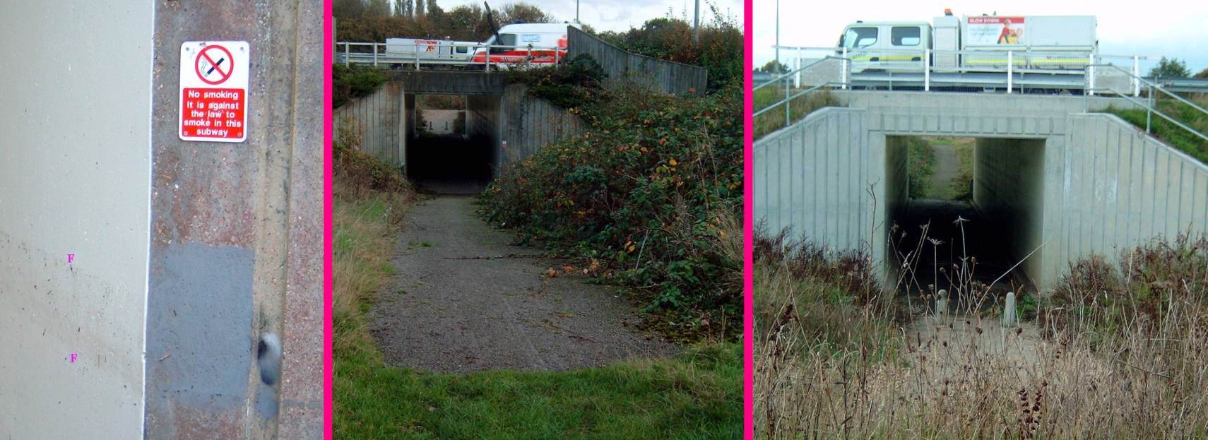
A surreal notice on a forgotten overgrown pedestrian subway at junction 5 of the M27,
visited only by a few adventurous dog walkers.
"No smoking It is against the law to smoke in this subway". So forgotten, there
was 4 foot of water in this underpass in the wet summer of 2012, tide marks
marked with Fs on the first image.
There follows a few infamous local road signs
etc.
The all time classic is the official sign in East St directing
people to the nearest toilets: NEAREST TOILETS BACK OF THE WALLS (Back of the
Walls is the name of a road)
In public lift in the civic centre. On
the door to the emergency telephone DO NOT PANIC Open the door and the phone
had been ripped out,on the panel behind was written NOW PANIC P.J
An undergraduate first going to an archaeology course in the then new
Arts 2 block in 1968 at Southampton University. He uses the lift there and
curious as to what was behind the little door marked "Emergency Phone" found
nothing inside not even where a phone could have been connected. 25 years later
he goes back for a reunion ,uses the same lift and yes still no sign of any
phone. P.C.
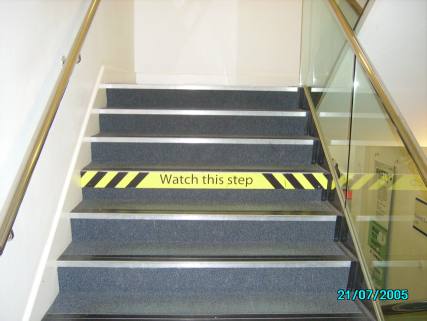
The idea of cues of autistic spectrum students watching these stairs in
the uni Hartley Library
Risers of the steps are 176mm except the marked one of 166mm.
Presumably like this video
http://dailypicksandflicks.com/2012/06/27/people-tripping-on-nyc-36th-st-subway-station-stairs-video/
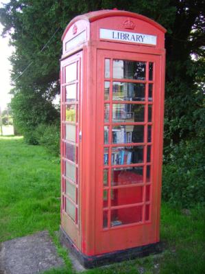
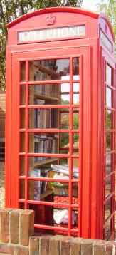
The telephone box library at Brown Candover, Hampshire
The library at Upper Clatford
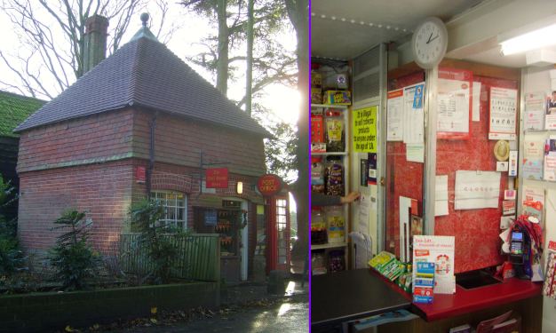
The world's smallest post office, 2 foot by 1 foot 6 inches ?
Closed at the time I visited , but otherwise open, in
the Well House shop and post office in Sparsholt. Not much headroom
either under the steel girders and bolted and rivetted water tank above their heads
Since the 1980s the local council has been trying to
shift the prostitutes out of the red light area and disrupting local roads to
deter kerb crawlers. To help this they have laid "sleeping policeman" in the
roads.Then they have placed numerous information signs around this area
directing the johns into the red-light district with the very explicit
statement: HUMPS FOR HALF A MILE In the top left
of this rather snatched photo Picture taken corner of Onslow Rd and Denzil
Avenue,Southampton Humps for 1/2 mile
Set
in the floor of the New Inn,Bevois Valley under the darts mat. FRANK ANDREWS
FELL HERE WHILE ON DUTY 14-3-82 On a 4 by 2 inch brasss plaque. This was
during John and Mo's incumbency. The duty was propping up the bar until there
was one of those quirky gravity waves that you get in public houses.
Another pub curiosity. A pub portrait of the Junction Inn, St Denys,
taken in July 1947 associated with a day out to Kempton Races
The picture hanging in the lounge of the pub is much clearer than this
photo would suggest. It is in a dark corner of the pub and a
glass covering. The names of the regulars are on the back
of the picture. Shame Ainsley did not do the same for the
Junction Pub regulars portraits of 1970s, 80s, 90s and 00s
also on the same wall of the lounge. Far more women
(genuine or faux) in the later portraits.
For anyone recognising any of the names transcribed from
the back of the 1947 picture they will have to visit the
pub to take a closer look. It still has some of the Victorian
features and in the 1970s the bottle & jug door was opened
in the afternoons to sell sweets to kids. An excellent way to annoy
the management in those days was to buy your beer at
2p less a pint in the Public Bar and take it round
to the lounge. I have no knowledge and no-one
locally now seems to have any connection with
any of those portrayed. The most intriguing individual is
the eighth from the left in the front row, a man in drag,
not alluded to on the reverse.
Transcribed names etc
The boy on the balcony is Mick Baker (landlord's son)
Front Row (from left) - Nobby Silverthorn, Nobby Parsons, Nobby Rogers,
Bert Terry, Mrs Baker (landlady), Percy Ruddock, Sonner Parsons, Jack Kirk, Jack Davis, ?,
Mr Wain, Jerry Dibben, Mr Philpott
Back Row - Hants & Dorset bus driver, Frank Baker, Charlie Andrews, Norman
Turner, Frank Read, George Wain, Peter Baker (landlord), George Scott,
George Martin, Joe Parsons, Mr White, Mr Holt / Martin ?, Harry Smith,
Percy Annett, Jack
In 2007 an interesting survey plan of St Dennis (sic) has appeared on the wall,
not dated but after the South Western Railway line was built but before
the Portsmouth branchline added , before St Denys station and before
Cobden Bridge was built (first opening 27 June 1883, second one
25 Oct, 1928). With just prospective roads for the area for
a land sale conducted by an Ellistons of 149 High St, Southampton
and surveyed by a Mr Deswell. Also in 2007 the old Commer ? van is still hidden
in the garden next to the railway. The landlord, Alan Mitchell, in the 1970s
put it there for reason now forgotten and not removed for curse or
whatever placed on it, 3 decades later, does anyone remember
the background to this odd event. ?
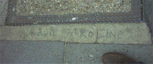
A ground level ,concrete graffiti, in Hanover Buildings 10 yards back to Queensway
from the High St junction scrawled in wet cement
RADIO CAROLINE
And to keep JT happy another "Radio Caroline " in a concrete strip outside
24 High St around the corner.
Newly placed bollards in Commercial Rd , where the dodgey "Roman Baths " were
and some commercial graffiti by someone who got his finger out promptly.
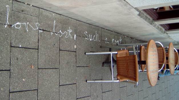
Neil Young dribble work outside the Costa Lota coffee shop in Portswood , Oct 2012,
Love lost, such a cost.
A 'drycleaner' with concerns for sprogladytes under the Brunswick rooms gospel church,
13 Osborne Road South, St Denys. Photo taken Dec 2004
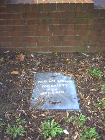
Painted on a drain cover - Zoe
REPLACE SCREWS FOR SAFETY OF CHILDREN
One time at 1 Osborne Rd there used to be an astronomical observatory, Beechwood Observatory. Large enough for a home-made 18 inch telescope, became home of the Southampton Astronomical Society under a Mr Mason Jan 1924 to post second world war, later occupied by the Rosicrucians
In
the 70s on a large sign fixed to the wall of the South Western Arms pub,St
Denys LIVE PIANO AT THE WEEKENDS
A quirk with this pub is its somehow acquired a Portsmouth Corporation lamp post
in the car park. 2007, the "witch"/Nellie is still suspended in the apex of
the roof space, now with bespoke underware. Hercules, the pub cat , litterally, wandered in and adopted the pub in 1998. He has been transfered
to the fourth set of pub managers, 2007, written into the contract of
transfer for continued care and maintainence.
The best behaved denizen of the South Western Arms - no swearing , no dirty jokes,
no talking politics, religion or football - sitting on his favourite bar-stool. Pics taken with available
light - well I don't like being on the receiving
end of camera flashes in pubs.
There is a superb genuine, not photoshopped, pic of Hercules sitting on
a folder left on the bar of the pub. Along the spine of the folder
is the title - Pest Control . He expired from old age Jan 2011 October 2009 the cat that adopted Romsey railway station
was still in residence.
There was a bakers in Queensway that
for some years had the perspex shop sign above the premises proclaiming: HIGH
GLASS CONFECTIONERS
A sign on a tattooist's shop on Portswood Road (near
the junction with Lodge Road) EAR PIERCING WHILE YOU WAIT KW The
alternative is too horrific to contemplate.
The following 2 references
are in memory of East Park Terrace lecturer Alan Lawrence now passed on
(reporter only not culprit) Dotted around the college in East Park Terrace
there used to be anthropomorphic signs saying THESE PREMISES ARE
ALARMED
In the 70s this college was called Southampton College of
Technology ,in the 80s it merged with Warsash Navigation College and a more
regional name was deemed appropriate. The name chosen was South Hants Institute
of Technology and duly forwarded on to the Winchester education committee to
ratify but someone there noticed what the acronym spelt out. It became plain boring
Southampton Institute instead. I see the Simpsons hometown has a Springfield Heights Institute
of Technology also.
There used
to be a door at Bolderwood Medical School that the sign was removed from so
often ,by medical students,that it had to be almost welded to the door,it
read PROFESSOR OF HUMAN REPRODUCTION
Twenty odd years ago there was a
poster campaign for Brain's faggots ( processed offal formed into meatballs)
some of these posters were placed on the ends of bus shelters. One such shelter
was outside the Merchant Navy Hotel at Stag Gates,Lodge Rd. The caption on the
poster read: GIVE A FAGGOT A GOOD HOME
In a similar but more
agricultural vein. For years I have seen a van going round town proudly
displaying on the sides DYKE SERVICES
A local engineer parked his
works van in the street. Little did he know he had parked opposite a
prostitute's house. On his return the woman confronted him requesting him to
regularly park it there. The company name on the side read COMPLETE GRINDING
SERVICES JH
A vacuum cleaner repair shop Spencers on the corner of
Rigby Rd and Portswood Rd,(now Zoe/Sim's coffee house) had the following sign in the window. WE SERVICE
GOBLINS JW Goblin being a manufacturer's name
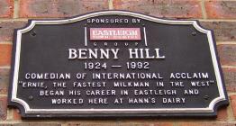
I recently came
across a posting concerning the comedian Benny Hill's house at 22 Westrow
Gardens,Southampton and no memorial to this local comic. Someone out of all the
world's comedians who managed to start a riot at a USA prison . The warders had
THIS PAGE IS INTENTIONALLY BLANK
changed association time to a different slot and the inmates could not watch the
Benny Hill show on the prison TV. It reminded me that i had associated a
strange,very narrow, little shop in St Mary St with Benny. It principally
supplied bulk stocks of condoms for ship's crews in the docks. I remembered the
proprietor as "Old Ma Hill" and thought she had a family connection with Benny
Hill. Now being familiar with the local archives i researched this.
The shop was near the original "Homebrews" shop but at 51 St Mary St
,euphemistically selling "medical supplies" proprietor R . Hills in 1974.
Unlikely for Hills to have any connection with Hill so unfounded. I checked
records for 22 Westrow Gardens in 1964 Helen F Hill and Alfred H Hill,1979 and
1987 Alfred H Hill. The last time I made a pilgrimage to Westrow Gardens there
was still no plaque of any sort. A local wag had ammended a nearby roadsign
reading Hill Lane to read Benny Hill Lane . As far as I know this is the only
recognition of a local noteable. May 2006 there was local media mention
of a statue to Benny appearing somewhere, maybe Eastleigh though.
At least a plaque in Eastleigh
The council will only recognize the likes
of R J Mitchell (Spitfire designer) not such onetime residents as Benny Hill ,Ken Russell
, Tommy Cooper or Danny La Rue.
There is a new
department of Southampton University on University Road the main sign outside
proudly says: SCHOOL OF NURSING AND MIDWIFERY DELIVERIES AT
REAR AK
On the now dental lab building , someone in 2013 has scraped off the overpaint to reveal a ghost from the past
An old wall painting advertising from 1940s/50s emerged in 2007
on the wall of the Triangle Boatyard , Bitterne Triangle. Had been covered by
a billboard frame for decades.
Graffiti has moved on a bit too. At the end of Regents Park Road there are
little triangular stickers (professionally printed by the look of it) stuck
on to the permanent traffic cones next to the traffic lights (the ones with
the blue circle and white arrows on) they read simply, KONART. (Cone-art) - RM
Anyone aware of the history of this sticker , is it covering a
smaller German anti-nuclear power sticker? The original went on the
back of this St denys Rd/ Adelaide Rd corner local lorry ban traffic sign
of the 1990s
I hand over now to an AM2 with his remembered graffiti and
his comments and photos for the next 4 or so items
Just come across the site. Very
fine. Can I tell you some of my favourites (now mostly gone but perhaps
preservable here)?
Pedestrian underpass going under Central Bridge Road,
south of Chantry Road. Early 1980s. A fan had covered one whole wall with ELLA
FITZGERALD IS GREAT. Very neat and large capitals, must have taken ages. A
refreshing change from the usual.
South corner of Earls Road and Bevois
Valley Road. There used to be a small terrace of houses, demolished and turned
into a carpark. The two-poster site was put up at the same time (mid 1970s). It
carried the usual warning, "Anyone defacing this poster will be prosecuted".
Very shortly afterwards, someone had painted out the last two words and added a
few so that the warning then read "Anyone defacing this poster WILL HAVE THEIR
HOUSE KNOCKED DOWN AND REPLACED WITH A HOARDING". An inspired defacement, I
thought.
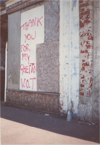
Photo taken St Mark's Terrace 1990s
"THANK YOU FOR MY GHETTO"
[ 'Thank you for my ghetto' one was part of a series
attributable to VOT, which stands for Voices of Treason, a local band with
an arguably enlightened sense of self publicity. - RM ]
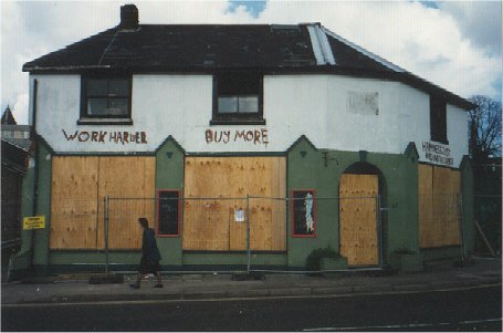
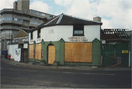
One time caf� in Station Rd behind Gaumont/Mayflower Theatre 07 April 1998
in Brave New World fashion
"WORK HARDER / BUY MORE / HAPPINESS JUST AROUND THE CORNER"
Another ear-piercing site: the now-demolished tattoo parlour in
Northam Road, just north of St Mary Street, used in the 1980s to advertise EAR
PIERCING SATURDAYS. Must have held good parties.
I, too, remember the
Invisible Menders in Oxford Street. From when I remember them (very late 1970s
and much of the 1980s), the shop was shut up and the windows covered in boards.
Obviously in a desperate attempt to disappear ,photo taken June 1982 Oxford Street.
Lastly, a telling piece
of graffiti I read on the urinal wall of the gents in the Bay Tree (as was; who
knows what it's called now?) around 1980. Somebody had written some post-hippy
gibberish about all being one. A second person added the words, I KNOW WHAT YOU
MEAN. BUT I DON'T UNDERSTAND YOU. On reflection, in its choice of words it was
probably more telling 20 years ago. - AM2
And to another AM, AM3
At Northam it was "Abortion, a women's right to choose" (definitely the
plural but there may not have been an apostrophe).
By the station it was "Cut the call up" (not "Ban", and the a" ence of
a hyphen allowed for creative misinterpretation).
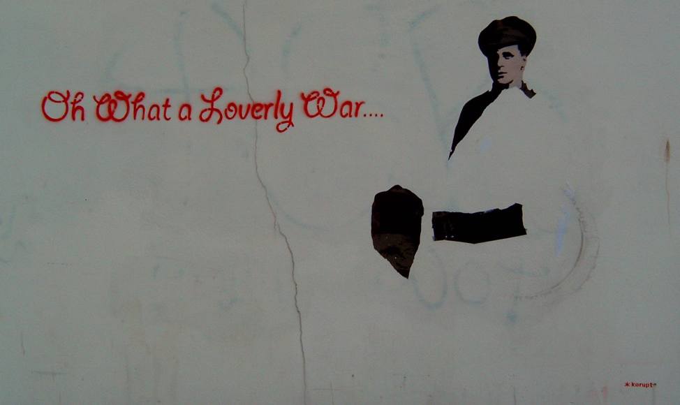
anti-war ethic 2011 style. July 2011
With creator mark, Korupt, in bottom right corner. Sub title could be (DC5)
"I'm in pieces, bits and pieces. But all you're doin' is leavin' me pain. " you referring to the MOD.
Corner of Weston Lane and Archery Grove.
The Bedford Hotel (Bedford Place) underwent a major makeover many years
ago, including the addition of some large, painted advertising high on a
side wall. Amongst other more prosaic offerings was advertised "Cooled
Largers", presumably to reduce the swelling.
At Four Post Hill there was a road sign that warned drivers to beware
of "Mereging Traffic". I couldn't identify such an activity, and
therefore always approached this area on the edge of paranoia (me, not
the area).
And do you remember The Junction's outside gents' toilet, inside which
was inscribed "Biggs", just that, but to which was later appended "But
not Biggs enough"? AM3
Just thought I would
share a particularly good quote from the wall in the gents at the Hobbit
pub. I'D GIVE MY RIGHT PENIS TO BE NORMAL G P
While on topic of
pub toilets. Named after the fisherman's gear store ,the Seaweed Hut, on Weston
Foreshore the nearby pub was named the Seaweed Inn . The toilets in this pub
were labelled HE-WEED and SHE-WEED
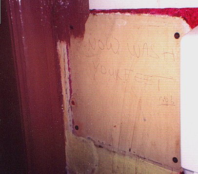
In the antediluvian bogs (or rather post-diluvian - yellow version) of
Leg-ends (ex Stoneham Inn) pub
in Bevois Valley. A proper (for the Stoneham ) sign on the bog wall.
Then, later, presumably a drunk painter could not keep the shit-brown paint on the woodwork
and part painted over it. Too small a bog to photograph straight on - all very sordid. ( AM2 and AK )
NOW WASH YOUR FEET
On the common in the 70s on the
exterior face of the brickwall of a toilet block infamous for cottaging. Painted in
large letters in mirror writing the way Ambulance is written back to front on
the front of the ambulance just in case the driver in front of it does not
register that a big object bearing down on him with flashing blue lights and
blaring sirens is not an ambulance. The script looked something like the
following sureality - A.G.
To my shame I remember seeing this writing on the wall but dismissed it as random gibberish. I walked straight past having failed to recognise what may be the most inspired and surreal grafffitti ever - Doh!
If you leave Soton railway station on the north side, just before the exit is a sign indicationg the exit (if you see what I mean). It reads:
WAY OUT
TOILETS
just like that, one above the other. Some wag sprayed man below the words...it didnt stay ther long, and was removed after about three weeks. - LS
As you turn the corner from St Mary's Road into the top end of Onslow Rd was a shop Danaan
(now October Books)
with a big window sign - LS
RECYCLED TOILET PAPER
A comment from Ken Higham of Manchester for
those against graffiti: "Why not sign a partition"
Contributions from Alys
I enjoyed your collection of little bits of street history.
Here are my additions:
FIND PAUL MILES at the Bellevue Road end of Onslow Road-Bellevue Road subway
from early 90s
SI**N HADDON IS A COPPER'S NARK in Kingsland Market late 80s/early 90s
RIO IS A THIEF Portswood High St near Safeway mid 90s
LE GOD FOR ENGLAND when Le Tiss was being overlooked
fly posters reading F**K WORK, LET'S ROCK and HEY KIDS, LET'S ROCK around
Polygon, London Road, ABC cinema 94 or 95
and another flyposter with a mugshot of a guy in shades holding a board with
writing in Spanish, about the same time, Onslow Road.
The Broadway Cinema Gribbles, Portswood
Now a bingo hall but this reminder of the onetime queues around the block , when it was a cinema.
Grinding into the soft bricks with coins
and on the other side
and continuing around the rear you can see from the Iceland car park.
Another example of human gribbles, one time Gosport Grammar School
, Walpole Rd, where they waited for the bus
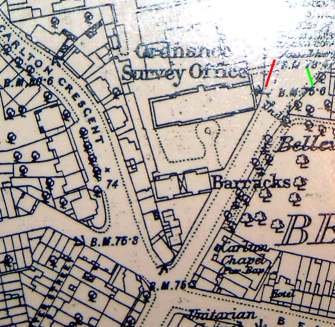
In Carlton
Crescent behind No 8. In its history it must have been part of Ordnance Survey,
Southampton. The rear wall of the building is covered in probably thousands of
benchmarks. Trainee surveyors must have used the wall to practise chiselling
these marks used as reference points in followup surveys. I recently checked
behind this building and it has been rendered over and this array of carvings is
buried ,presumably ,never to be seen again.
Few references to the OS
having been at that site, one seems to be what looks like
a grave in front of the Crown Courts marking a Fundamental Bench TP0541 primary trig point
or perhaps a disguised manhole. Grid reference SU 42074 12802 , apparently 74.3510
above chart datum Newlyn , the original height in ft has been blocked off with a bolted
brass plate. Is that because the reference point is different, more accuracy or Southampton is sinking ?
The height of that BM on a 1910 map was recorded as 75.6 ft. The 1878 map
also records it as 75.6 with the sort of odd info that you don't see
on OS maps these days "Roman coins found here".
Despite being ancient it now has a nasty
modern plastic plate addition saying it is part of
the National GPS Network, now thats what I call a geostationary
orbit. An ancient pre-OS levelling mark? if GR means during the reign of
the first King George and War Department broad arrow rather than OS cutmark form. Again the original brass plate removed like the others around the country. This one in Russell Place, Portswood Southampton, nearly opposite where Spitfire designer R.J.Mitchell lived.
http://www.diverse.4mg.com/BM_GR.jpg
In the Maritime Museum,at end
of French Street inside the building in the upper levels there are the names of
French internees during presumably the war of Spanish Succession. Some I could make out were
MARIE TANGRE in roof-truss timberwork above the West wall
? THOMA: and date perhaps, but like all these scripts need oblique lighting and a
pair of steps to read them decently, this time on a cross beam at South end.
FRANCOIS DRIE
THOMAS LAIS
on one stone and
N 1711 ( the 7 is shaped like the right half of a letter M ) presumably the date Novembre 1711 on the stone beneath it in the surround of a window in the West wall
Also downnstairs near the main entrance is another stone that may be
reset upside down with some more indistinct script ? AKOV?
In Tudor House Museum,Southampton. There is grafiti in
the attic courtesy of ARP observers during the war. In the "ship room" there
is scratched onto the plaster ships,ropework and rabbits. Also preserved there
but transferred from the attic of the Banqueting Hall a plaster scratchwork
dated to about 1750. This is of a two deck,three masted ship with admiralty
pattern anchor and chain and Union Flag.
From the Echo 6/9/2007 a carpenter's beef, carp carved on a wooden beam
"1936 Fed up beer 7d a pint" signed L. Sykes and J. White
Beer had last risen in price 14 years previously, negative inflation over that time apparently
Behind Tudor House Museum on
Western Esplanade is an intriguing piece of brick wall. It is about 30 yards
from where Blue Anchor Lane emerges and looks like it belongs to the de Vere
Grand Harbour Hotel . An interesting piece of wall in
its own right. Five foot 6 inch high soft orange brick with a coping of glazed
semicircular blue-black bricks and a string course of tiles. Scratched into
the brickwork are the names of American service personel stationed over here
during the war. The official "politically correct" record is they were killing
time waiting to embark for D-Day. From local oral history the wall was part of a
VD clinic for American services personel which agrees better with one of the
dates scratched being 1941 and another 1937. I hope the days of sanitized
versions of history are gone and we can now have a "warts and all" truer
reflection of all events. This wall needs attention to halt further
deterioration of the spalling (frost damage) surface of the brickwork and the
carving with it. In a sense the two year old growth of ivy flopping over from
the other side is protecting from frost but will soon start rooting into the
brickwork and longer fronds in the wind will abraid. If anyone ,particularly in
the States with relatives who served in Britain during the war would like to
contact me to have a photographic survey / conservation of this wall it will
give me more clout when I make representations to Southampton Council or whoever
owns this wall . I will take it upon myself to monitor this ivy etc.It is such a
tangible memorial to fraternal links across the pond that I am sure justifies
some care spent on it. If given permission to temporarily rope back the ivy for
an afternoon and couple of hours at night I would photograph it myself. There
are probably another 15 names hidden too indistinct to make out or lost from
frost damage etc.The clearest is shown in this picture is that of Mr
Eatherington.
So some of the names still
very readable: W. E. SHIRK Wm MUELLER CLEMTATIO JOE HAMMOND H. L.
EATHERINGTON - ZION T/S ROBERT M. RAY AND DAVE RAY OHIO ROBERT GOLDEN Geo
FABER OF COLO. JAMES HENLEY LAWRENCE MATHIS 1941 DEC 23 JAMES ?DES
PENNY VIRRLA PENNY CALAVERY AMER??D CHICAGO ILLINOIS F. F. JOHNSON
USA JOE N. JONES DEC 22 1944 D. W. SMITH J. C. KELLOE CHARSTON
S.C. BILLIE WILSON P W ?AAL RALPH ODEL J L PLIEL JONY
JOHNSTON BILL ?URBAN W KNIGHT
And on the small, reconstructed patch hiding dustbins,
of wall behind from bricks from a demolished section of this wall in jumbled order M P CARTER
AUG 44 M J WOMPON FEB 45 ? F RECINE OCT 10,1944 FRANCE P D B?EECH
CATAWISSA PENNA J C CHRISTEN?N ALDEN BOLL M???NN G N BUNKER ? CITY
IOWA 1945 BALTIMORE EDDIE MEYER ILLINOIS 17/21/44 JOHN HELMLIIIO
ELYRIA OHIO 11-4-44 DOOLING BEVERLY MASS R FINN J E WETTA CALLAWA MIAMI
FLORIDA LAB RY MT NC ED C??BA??K BOUND BROOK JO COURT ? M SLATER
MAY 13 1937 VANEE MARTIN VA I have transcribed as best I could but some
letters are deteriorated and indistinct and I may have confused names and places
also later repointing has lost part of the words. The reference to Zion is
probably the place near Chicago rather than a double barrel surname. I hope
the same doesn't happen as another wall I was aware of. This wall perhaps 25
foot high in Marine Parade ,Chapel,Southampton. It was part of the gasworks but
it had the only example of wartime fighter strafing bullet marks that I was
aware of. It was demolished recently to build the new Southampton football club
stadium.
A couple of wartime stories told to me but I've not heard confirmation of.
In the Northam area near this old gasworks strafed wall. One day a german
fighter was shot down but the pilot managed to bale out and landed safely in
Northam Rd near a cinema that is now the area of the regional TV centre. Within
a matter of minutes a number of local women had come out and had kicked him to
death. No one was ever charged with this murder and all covered up. The German
fighters made a habit of straffing the local streets at precisely the time local
kids were making their ways home from school. Then in a different part of
Southampton not so affected by the intense efforts to knock out the Woolston
Supermarine Works. Padwell Rd in the Inner Avenue area. Some bods were drinking
in their local and a German fighter plane crash landed. The pilot survived but
dazed. The locals dragged him out of the wreckage and stood him drinks in the
pub while waiting for the relevant authorities to take him away.
I have surveyed the "American" wall. It is well worth going on
one of the guided walks of the old Southampton city walls as you are let into
some of the late medieval vaults along the route. (Make sure you go on one that includes
a look into the alms house "lost garden" in Winkle St.) From where Blue Anchor Lane emerges
then 62 foot northwards along the old walls then 70 foot perpendicular across
Western Esplanade is the start of the wall. It is 44 foot 6in long with a return
westwards then a stone wall continues for 65 foot 6in curving slightly westwards
then a westwards return. This agrees with the 1:2500 map of 1934 and the
1:1250 map of 1948 showing a walled complex of morgue,VD clinic and another
unamed building to which the wall of interest is externally associated. This
anonymous building has 2 covered, maybe, veranda areas. In 1921 this building
appears in Borough Engineers plans as the County Borough Disinfecting station.
It is recorded as this in Kelly's including 1940. If this is it then the
verandas make sense as do the mention of 2 pairs of brothers .Isolation of
familial contacts for smallpox or whatever is more likely than 2 brothers
getting clap from the same source. There remains one mystery the script on
the wall is on the public side of the wall not inside the enclosure.
ps
e-m received 3 May,2001 Nigel, My brother M found your web page,
http://www.divdev.fsnet.co.uk/graff.htm and called me. Our father was
stationed in England during the war, H. L. Eatherington, from Zion, Illinois.
How incredible to see your picture -- of his signature on the wall, his
graffiti. I hope you are successful in preserving the wall! Let us know if we
can help. F. Eatherington daughter of H. L. , and sister to M., P. and D.
Eatherington January 2002 the ivy was cut back off this wall and there is now
official confirmation from the City Council that this wall in fact belongs to
the hotel not the council.
To save having more emailed enquiries to me trying to locate this wall. On http://local.live.com/ enter
postcode SO15 1AG, the graffiti wall is under the tree just to the SE of the
distinctive octagonal roof of part of the hotel. Featured on the Old Town American Trail http://www.visit-southampton.co.uk/dbimgs/Old%20Town%20American%20Trail.pdf
Blue Anchor Lane is now only a footpath so not on maps
The overlaid red circle on
MAP
represents roughly (centre should be other side of Bugle St) Tudor House (postcode SO14 2AD )
Museum
The lane starts along the right hand wall of the museum in that pic
and goes down to
Blue Anchor Lane
arch which is in Western Esplanade, the graffiti wall is then roughly on the
opposite side of the Esplande to this archway in the medieval wall, the old wall viewed to
the right through this arch encloses the tudor garden and bower behind the museum.
The Historical Mystery Explained?
I did a bit more research and
have identified the building next to this wall. It was the Borough Disinfecting
Station. in 1940. I have seen the 1921 engineers plans for the building and it
would appear to be for disinfecting vehicles not people.
So as H.L.Eatherington was in the transport corps all the time he was in
England all of his war service (information from his relatives)then the
following is the most likely explanation sofar. The daughter (from the USA) of
Harold L. Eatherington visited his "graffiti" on 31 March 2002. Also his son
visited June , 2006.
There would have been vehicles coming from the States to the docks
throughout the war not just the huge build-up for D-Day. It was probably
necessary to disinfect from Colorado Beetles etc before driving to Army bases
around the UK. There was no room inside the walled compound around this
disinfecting station to queue up vehicles. They would have to park outside.
Perhaps a tradition built up "signing " this wall while waiting in a queue for
processing. If any more of the names on the wall were in the transport corps
then it would be pretty good confirmation of my theory. It explains why all
American names,the dates span and the outside , public side of the wall. The
only slightly odd thing remaining is the reference to 2 sets of brothers
names.
Some more wartime evocations, some of the window glass of Hut 4. Bletchley
Park, not mentioned on their site so detailed here
The hut next to the mansion that moved 1m off its foundations
when a bomb landed in soft ground and exploded deep about 50 foot away.
Presumably glass replaced after the bombing and then covered
in gummed strip. The trace of gum still there over 60 years later.
Most of the window glass is modern , but some original
panes remain. The modern glass is clean, so not some moodern
themed evening event, confirmed by one of the aged seventy-something guides.
Sitting in the cafe I noticed some of the window
glass was old slightly bubbled and rippled and then if
you view at the right angle you can see the X marks.
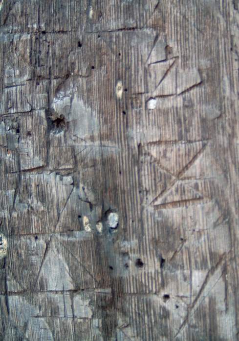
Canadian carved graffiti
This one in the residential part of Freemantle but as a private address then
not disclosed any more than that.
No one locally has the foggiest explanation for the carvings.
Needs a close-up lens to photograph properly, I'll take one
the next time I visit.
The house was a cobblers at some point in its past as the floorboards are peppered with hobnails.
As the carvings are between 4ft 6in and 6 ft 6in off the
ground and perfect spelling and almost stonemason quality carving ,very
unlikely to be children.
Carved pictures of native Canadian raised prow fore and aft canoes and
wigwams etc .
Only one text seemed a bit child-like.
"SILVER MINE AND GOLD MINE HIDDEN 1878 HORSEHEAD MONTAIN"
There was even some script that looked runic the up-arrow for "t",
inverted Y for "c" , single S of the nazi SS symbol of "i umlaut",
cross of "n" or "a" and Y for "k"
Other scripts, each one occupying just one brick , so surprisingly small
script.
"THE DARING SCOUT A SKILLED GUIDE A BOLD RIDER AND A BRAVE TRAPPER" with a
bowie knife and a scimitar shaped blade
"31 FT NORTH CANADIAN SCOUTS 1868 / 1872"
"PRISS THE TIGER 1862 TO 1871 CAME INTO THIS HOUSE 1887"
"TRAPPER TIM AND PRISS THE SCOUT WHEN THEY CAME IN THE BOYS TURNED OUT"
close up of the 31FT
"31 FT NORTH CANADIAN SCOUT RAYMOND P PARKES KNOWN IN THE FAR WEST AS PRISS
THE TIGER ?R DARING ?L OF 9 YEARS"
A badge with shield shape with an up-pointed fletched arrow on either side,
upper left
quarter of the shield letters "UI" , top right 1/4 something like 2
interlocked pitchfork heads (interlocked E and reversed E but turned through 90 degrees), lower left 1/4 a heart and lower R 1/4 a shape
like a deer-head face on
a very intriguing house with shingled roof, a door and 4-pane window at
ground level but 3 arrow slit type windows on the upper floor
a couple of crosses and faces etc.
There was a Victor Parkes , carver and gilder in the 1895 Kellys
at the address.
He was probably the father of Raymond Parkes and grandfather of Raymond
Percy Parkes in the 1881 census shows a Raymond Parkes (head) and Raymond Parkes (son).
My conjecture -
It was probably a Victor Parkes , carver and gilder, who carved the bricks.
Something like
Spike Milligan's Elfin Oak in Kensington - to enchant children.
He probably carved them in 1887, for his son Raymond Parkes' children,
his grandchildren, as a sort of picture
book. It would be interesting
if just 2 letters FT rather than ST and the carefully carved native Canadian
context pictures directed back to a Canadian origin for the otherwise
unknown
Victor Parkes.
Remains the question , why so high off the ground if intended for children ?
The 31FT reference is in, as far as anyone knows, to the ficticious
"31 FT North Canadian Scouts" having these presumed adventures in the wilds
of Canada.
More pics of the brick carvings Trapper face wigwam cross 31FT wigwam cross 31FT badge scimitar face
Some other local pages Bitterne Park St Denys Peartree Green
Added here for no particular reason other than I could find no internet
reference. I visited Bishop's Waltham , Hampshire and noticed a number
of chimney pots with a fired-in white line around the pots about 3 or 4 inches
down from the top. I asked a local builder working on a nearby job if
he knew what these white rings represented. I seemed to have picked
just the right person to ask. An ancestor of his had worked for the
local Blanchards terracotta factory. It was their trade mark, in effect,
for their chimney pots. Unless you got to Fareham or Porchester and
they claim them for themselves or maybe 2 line/3 line or
wavey line variants Mansard roof at 172 Castle St, Porchester Ditto High St, Fareham with one of their
early 1897 civic electric light lampposts, pipped to the post by Godalming High St, Fareham A complex roofscape behind 46 ? High St, Fareham
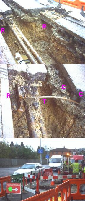
A small study into mains electricity failures. Part of St Denys blacked out for 4 hours.
This being the cause, the errant joint was laid by the trench so I had
to nose.
Mains outage
I laid a foot ruler laid over for scale, 15 Jan 2011 a couple of weeks after the Dec 2010
severe cold spell. A few hundred houses affected but I
assume this cable only supplied a few dozen, then the linesmen isolated the
area transformer to fix the break , or do they work live? .
Two cable ends marked by "O" . Tar infill not obviously burnt, just what
seems to be an inadequate crimp had partly melted off the left hand end. I
somehow expected something like a phosphorous cauldron like they use for
welding railway line - not a crimp.
And certainly not an open crimp as showing the flute betwen the "o"s in this
closeup Mains outage , cable joint of sorts
Orange is probably clay pipe surround, along with lead sheet inside that and
then tar. Remaining cables showed no damage so no shorts.
The end of the cable is cut clean across the wire strands and no sign of any
brazing or the like. Wire strops and marine hawsers use a closed ring crimp
hydraulically compressed on. How much of a bang would such 1 inch diameter
cable failure make a couple of feet underground?
Herbert Collins Trail
Herbert Collins Trail
The full file contains a lot of pictures so only the text and
thumbnails placed here.
An exploration, by walking, the main areas of houses designed by local
architect Herbert Collins and taking in some interesting sights
along the way - how many people would say there were no thatched cottages
in Southampton ?. [postcodes in square brackets for entering into http://local.live.com
or Google maps for aerial views ]
The main streets containing Herbert Collins
houses are marked with a red "H" on my map and numbers
referring to the photos . I've made it a circular
walk starting in Abbotts Way, Portswood, close to where he
lived between 1930 and 1973.
The walk, excluding any exploration
of the Swaythling/Mansbridge estate, is about 7.5 miles long.
By the end of it you should be able to recognise a Collins house
anywhere. His main "signature" is highlighted on picture 9 ,the 3 slivers
of tile, placed instead of a single brick, sometimes as header, sometimes as
stretcher. Making a virtue out of necessity, filling in the holes in the
brickwork, where the wooden scaffolding had purchase, putlogs/putlocks.
Also the visual illusion "arches" over window reveals. Complex
parallelogram, or maybe made as wedge-shape bricks, in a fan pattern with a protruding "keystone"
of 3 bricks at the centre. Doors that are 5 inches wider than
normal, for coach-built prams. He liked to use pantiles on the roofs and
header string courses in the brickwork. Makes you wonder what happened
if the brickies missed out any of these features. He seemed to like
planting apple trees, - eaters,cookers and crabs and even trellises
are part of his signature. How about this Southampton tree, the only remarkable thing about
it is, its unique in the UK - the Champion Tree a cross between a pear and something else.
I wonder if there
is an image processing plug-in for auto-removal
of wheelie bins ?
Blue numbers on the map indicate the photo number and the blue line
the direction found in and around the map.
(1) is 38 Brookvale Rd with blue plaque, showing HC lived here 1930 to 1973.
Opposite there is a short walkway to the end of Orchards Way [SO17 1RF]
and Uplands Way. (1) shows on the left the shingles covered
spire of the church (2a),(2b) - unusual for UK. To cover this
area fully you need to backtrack on yourself a few times but its
well worth it. Post Box (4) with plaque is at the first bend in OW. (3) is
Highfield Close with ornamental pond [SO17 1QZ]. (12) is Glebe Court [ SO17 1RH].
(10) even garages have their own pantiled pitched roofs,
unfortunately Austin 7 size. The modern equivalent of coach-built
prams got smaller and the replacement for Austin 7s got larger.
(13) and (14) are 68-78 Highfield Lane going up to High Crown St.
Unfortunately there is no exit down High Crown St so next to the
pub you have to turn left into Hawthorn Rd, then Oakhurst Rd
to join the path on the common. This path skirts the university, ignore
that fork, to the right,
and keep natural untended woodland on the other. Cross Burgess Rd at
the pedestrian lights and go
up Glen Eyre Rd.
At the mini roundabout turn right then left
into Copperfield Rd, First left into Parkway then left into Hurlingham Gardens.
Up the stepped footpath and turn right into the path that goes between
the two arms of Parkway or get to the continuation of this path via the narrow
path opposite No 45 .
Down to the brook with a sign showing it to be Forestry
Commission ground. Then over the bridge and along
the made-up path uphill and you come out at The Orchard
area of Bassett Green Village [ SO16 3NA], not down the raised boardwalk
going in the same direction as the stream to Daisy Dip. (16) and (17) are on Bassett
Green with another interesting house (16a) between those 2 and
also on bassett Green Rd opposite the junction to the green.
(17) is St Christophers with its own sewer vent pipe.
Don't miss out Field Close [SO16 3DY]
and Binstead Close in the area of Ethelburt Ave [SO16 3DF]
all with unadopted roads. Ethelbert name conflated from his name and that
of his sister Ethel. HC houses are only in the lower
end of Leaside Way. The bungalows in Summerfield Gardens
maybe HC but according to a local resident he only knew they
were built by Tizzards in 1950s.
[Tizzards: they built the
Med-style bungalows in Moorhill Gardens (SO18 5BR & 5BS) (near Kanes Hill
roundabout), to HC's design. Kootenay Ave is a Native American name, from a Canadian National
Park he and his family visited. I gather his father had owned the land along Thornhill Park
Road, which was furnished with Collins homes.
The 1932 Swaythling Methodist Church (with the copper dome), Manse and
associated buildings, and the Burgess Road Library are also his.]
There is a small path between
Summerfield Gardens to Greenways then L, first R, in Stoneham
Lane and down Channels Farm Rd to (21) Channels Farm House.
There are 2 paths either side of Phillimore Rd to
get to Market Buildings residential/shop developement.
Under the railway arch (Black Arch) , back at the end of Bassett Green Rd
on corner of Wide Lane is another HC commerce developement.
Unfortunately practically all the houses in the Swaythling
and Mansbridge area have rendered elevations.
Going down Wessex Lane you come to Connaught Hall
[ SO18 2NS] and then around the bend Montefiore House.
At the bus stop go into the grounds of the hall,
down the track and behind the church is
some sort of neglected hidden garden which onetime
probably had statuary but now just a Portland stone
edifice and cut beech hedge and lawn.
Doubling back at Wessex Lane the access to the 12 century South Stoneham
St Mary's Church looks like an access road to Connaught
Hall of student residence. The footpath goes between
Connaught and the church. Don't be tempted to stray towards
the river or you may get a shotgun levelled at you from the
keepers of the salmon hatchery hidden in that area.
Herbert Collins estate is off to the left of this path [ SO18 2LS] .
Continue on to Mansbridge , that tiny humpback bridge
was part of the A27 up till the 1970s. There is a sign
here for the start of the Itchen Navigation walk up
to Winchester. If you should do that walk , inspect
the remnants of the "flash locks" on the Itchen Navigation
and research how they were used. The return leg of this walk is
along the River Itchen, freshwater section to Woodmill
and then tidal after that. A beauty spot at Saltmead next the sewage works,
St Denys, on the other side of the tidal section of the River Itchen. Some would
pay silly money for such as an installation.
Its that frisson of contrast
with the lime-green weed that has serendipitously drifted down from the clinical upper Itchen
over the monotonal fluvial mud, failing to disguise
the all too familiar man-made forms - pseuds corner. As others have also appreciated
this pic I've uploaded a higher resolution version of the image.
Anyone care to sponsor me, to re-create this image as an
installation for the Tate Modern ?
2013 in response to the numerous anti-flytipping and anti-dogfouling
posters, bags of dog shit displayed on the riverside fencing.
Incidentally the pic also captures the shit-barge returning from the Nab Tower dumping ground, small tug lashed athwartships under the bow as a bow-thruster as well as larger stern pushing tug.
There are more HC houses in Southampton eg
Thornhill Park Estate, Ascupart House Portswood Rd, medieval Bitterne Manor House
conversion and addition etc, if anyone shows interest I could do a followup.
Council car parks are marked with red "P", the one at
Parkville Rd, opposite Market Buildings, Swaythling has
an impressive display of tag graffiti. Gypsy Grove, 1/4 mile track in Shirley is also a tag "gallery".
Herbert Collins Trail
More walks in the Southampton area
Doe anyone know of an index of these HC site walks?
http://herbertcollins.co.uk/home/content/view/109/2/
http://herbertcollins.co.uk/home/content/view/30/2/
http://herbertcollins.co.uk/home/content/view/103/2/
http://herbertcollins.co.uk/home/content/view/121/2/
http://herbertcollins.co.uk/home/content/view/135/2/
http://herbertcollins.co.uk/home/content/view/78/2/
http://www.southampton.gov.uk/leisure/events/july-september/Jane-Austen-Trail-and-Other-Walks.asp
http://www.whitenap.plus.com/itchen/itchen_acess.htm
http://www.britishwalks.org/walks/Counties/Hampshire/index.php
http://www.hamblevalleyheritage.co.uk/
The Japanese ethic of 2 storey homes at Meggesson Avenue, converted shipping containers
Right next to an electricity substation , at the right of the lower pic
Some Further Observations
Off topic but an interesting play on
words. About 1982 to 1984 at the local newspaper "The Evening Echo" there was
a matter of pride in sub-editors smuggling homonyms into titles and getting them
past the editor. Probably the best one to get through and be printed was the
headline ARRESTED MAN HAD PISTOL DOWN HIS TROUSERS
Does anyone recall
another more recent such headline? Something like "Locals: mass debate over
mobile phone mast"
Does anyone have any recollection of the following.
A few months after the start of the Southampton Advertiser ,freesheet. A mother's son
had just been put inside and she was disposing of some of his stuff in the Advertiser. Text
of ad read something like " SAWN-OFF SHOTGUN FOR SALE, NO LONGER REQUIRED, USED ONCE - CONTACT ...... MILLBROOK TOWERS"
There is an expression ,probably Pompey navy slang,
"Getting off at Fratton" even the ozzies have there own variant referring to
Sydney something like " Getting off at Redfern". Could we have a version
"Getting off at St Denys" . They are all the penultimate railway stations to a
destination alluding to coitus interruptus.
In Memorium to some street
characters. "Maryland" for busking in Above Bar defending his pitch with
determination. The "violinist" in the subway next Kingsland Market. Any
donations to him were in a vain effort to shut him up. Ruth Mary Bundy for
outraging public morals. I was told she was a nurse before personal difficulty
and descending to the street. I got hold of her collar and dragged her from a
totally unlit part of the middle of Duke's Rd one night. She was collapsed and
out of it and I dragged her onto the pavement. She never swore at me after that.
She had a habit ,summertime ,of patrolling Bevois Valley and reaching through
open windows of the pubs and nicking people's drinks. The tramp at the bottom
end of town whose clothing was rags tied together with bits of coat-hanger
wire. The following I stumbled on in the Echo archive looking
for something else.
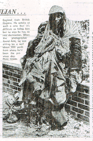
Taken from p4 ,04 August 1973
Accompanying text: Meet Julian
This chap has been seen around Southampton for some time now,and said that he didn't mind at all if we took a picture
of his amazing get-up.
He wears - by the look of it - everything that he can get
his hands on....several jackets and coats,various pairs of gloves ,scarves and trousers. On top all that,he's adorned with plastic sheeting,strips of rag and newspapers,and odd shoes.
He said his name is Julian Barrett,and that he came to
England from British Guyana. He speaks at such a rate that it's difficult to follow him but he says he has no real destinction. When
the photographer ( Holmes) found him he was sitting on a wall
about 200 yards from where he'd been the previous day.
Next
The retired schoolteacher who lived near Mount Pleasant Rd who took his
guinea pig for walks on a lead. He moved on from ice-skating to wearing a monkey
costume and skateboarding along the roads. Diving down the subways much to the
annoyance of the cops who he always managed to evade.
St Andrews church door , Hamble. Mysterious runic-like or mason-mark-like carvings supposedly
concerning local seafarers off to sea leaving a vertical mark and returning with a cross-mark, or not.
You can almost dendrochronologically date this door from the tree rings in the pic, unlikely though
to be mediaeval , even late medieval. The central dense layering of rings core wood , or a string of cold years?
Bitterne there used to be 2 landmark spires. The
parish church one still there, but what happened to the St Colman Catholic church one
, next to the library?
Someone in the library , someone in the Bitterne local studies charity shop
and 2 other people remember it but no one knows when, how or why it
disapeared.
How can
something like that just disappear without anyone noticing
All people roughly agree with how I remember it. 2 columns with a brace
across the top and a bell slung between them, not as high as the parish
church spire.
pdf on http://www.southampton.gov.uk/moderngov
"Bitterne Road East Catholic Church of Christ the
King and St Colman, and Presbytery
1960. Modern church by EM
Galloway situated on a prominent
junction. Reinforced concrete and
yellow bricks with copper roofs.
Landmark bell tower demolished
2008"
Copper roof is still there.
I seem to remember the columns were like concrete street-light columns but
twice the height and lots of them have spalled concrete from rusted rebar,
so an elfin safety matter presumably.
I expected info on the web about the dozens of dozens of distinctive holes in a couple of bays of the north wall of Romsey Abbey, but no.
Holes have a hemispherical end surface, firing squad execution by musket in the civil war?
The most likely explanation I've heard so far: The psychology of the time, god and his works was the only perfection in the world, any work of the hand of man must therefore be imperfect, so deliberate blasting of the abbey walls to give pock-marked blemished appearance.
Some Woolston and also Netley trivia. Both railway stations have the same retained heritage oddity in the station canopy, adjascent to the booking hall. Cut away to allow a bit more daylight
into the booking hall to save some gas early mornings and late evenings
in hte gaslight days. Feature retained despite replacement of the
timber slats. This one Woolston station.
A house in Netley , station rd junction, must have
caused problems at conveyancing, ownership of the half/half split in the
doorway ownership, also strange roof angles on the left house
At the entrances to the Royal Victoria Hospital, Netley some curious tapered hollow fencing posts, topped with crowns and legent just under the crown Mortons Patent Lines or Hortons Patent Lines or something like that.
Perhaps Francis Morton's Patent Strained Fences , 1859 or since.
Again slightly off
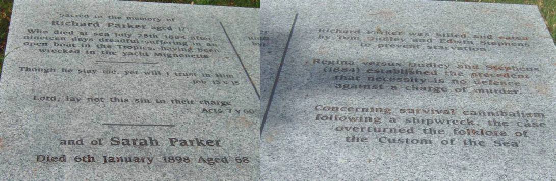
topic now but a curious local story In the churchyard of Pear Tree Church
(Jesus Chapel) Woolston Southampton next to the church is the following
recumbent memorial stone to one of (part Woolston) Itchen Ferry's lost
sons Sacred to the memory of Richard Parker aged 17 Who died at sea
July 25th 1884 after nineteen days dreadful suffering in an open boat in the
tropics having been wrecked in the yacht Mignonette.
By 2011 a larger memorial has been placed here. As a memorial rather than
gravestone then presumably the socio-political comment is allowed
"Richard Parker was killed and eaten by Tom Dudley and
Edwin Stephens to prevent starvation"
Composite, because of the angle of the stone , to photograph as
one image, would require climbing on a tree or gravestone or using some steps.
For anyone
surviving in similar circumstances make sure you stick to the story that you
drew lots before selecting and killing your foodstuff. To save me writing up
I take the liberty to cross-link to The Story of the
Mignonette The following is part of the three column report on the 5 Dec
1884 in The Times,page 3 . For any local history,legal history or maritime
history bods I have a printed version of the whole article. Report of the trial in The Times
And truth stranger than fiction
the Edgar Allan Poe prediction ? http://www.psychics.co.uk/coincidences/cannibal.html
Another odd death , of Douglas R G Lane, killed by lightning,
grave in Southampton Old Cemetary on the common
Some odd and interesting snippets of local history
Hampshire Chronicle - What we said
May 2015 what has happened to the unique? commemoration of a non-event. Commemorating that at this spot nothing much happened on a specific new years eve celebration.? A brass cross marking the spot in the pavement outside the
remains of Holy Rood Church. Recent repaving of some of that area and this paving slab has been removed. From Southampton Pictorial 01 Jan 1913 " The bells of Holy Rood is the rallying point of Southampton , like the bells of St Pauls, Notre Dame and the Kremlin. Such a crowd was that assembled on the occassion of a fall of a mass of stone from
the tower many years ago. By a miracle it fell in the centre of a
dense-packed gathering without doing injury to a single person. The brass cross which was let into the pavement outside the church , marks the spot and the occassion."
Stone coffin in St Denys Church originally from the priory
of St Dionysius nearby, big enough for someone
6 foot 8 inches. Locals to Priory Close / nearby
Priory Rd area speak of hearing ghostly bells in the middle
of the night on some occasions.
A jumbled collection of encaustic tiles from St Denys Priory
(built 1127 ) also displayed in the church
This church has a very old organ , transfered recently , but
originally built 1756 with maybe part of it built in 1690.
Any local bods with their own favourite remembered grafitti / graffito I
would like to hear from on
A reserve email account is diverse9(commercial at)fastmail.fm.
Please make emails plain text only , no more than 5KByte or 500 words.
Anyone sending larger texts or attachments such as digital signatures, pictures etc will have
them automatically deleted on the server. I will be totally unaware of this - sorry, again
blame the spammers.
Anyone with any background info and I could add
an acknowledgement if OK. Please make any emails to me less than 5K or 500
words. Anyone sending larger texts or attachments such as digital
signatures,pictures etc will have them automatically rejected. I will be totally
unaware of this - sorry,again blame the spammers.
For years I have been trying to locate the world's best/worst postcard. I've
only heard it described but would love to see it or even just a copy. It is
presumably a postcard of Leeds, Yorkshire,since 1960 but whether still printed
I've no idea. The picture is mainly acres of crushed brick of an urban clearance
site. Just visible in the background is a gasometer. In the foreground is just
the corner of a brick built building . There are no people shown or anything
else. The title is the killer :- VIEW OF THE GASWORKS FROM ARMLEY ROAD
TOILETS
The next best postcards I have seen are 4-view cards "Building sites of
Basingstoke " and "Pedestrian Underpasses of Croydon".
Nigel Cook
There now follows
a plug for The Candleclub,Southampton This is a very popular amateur performance show held Monday evenings at the
Talking Heads pub,Portswood Rd. Now with top notch sound system .I don't think
any act has been refused but is usually singer / songwriter /guitarist. Any
Petomanes out there? or Zapadnyj Sajan Tuvan throat singers?. It is
non-profit,free entry for performers (just turn up on the night,early,to book a
10 minute slot) and free entry for audience. By consensus and audience reaction
the most appreciated act is invited to a monthly half hour showcase. There is
easily an audience of 180 and 12 to 15 acts. No one is ever booed off
stage, those first timers who make a hash of it usually get a resounding
applause for effort and not sarcasm or derision. Soon after they started it
Clive and Simeon were running into problems with acts going over their alotted
time slot. I said they should install a bank of 3 coloured lights as used on the
podium of political conferences. Clive said his brother had hanging around a set
of traditional traffic lights. So I said I would convert them with adjustable
timers for an unmistakeable stage reminder. Adjustable times because about 10
minutes on the Mondays and 30 minutes on the Sundays. No more disapointments for
acts squeezed out at the end of the evening. An inside tip for anyone
wanting to increase their chance of a halfhour session - turn up on a Bank
Holiday Monday as few acts turn up on those days.
And a puff for a duo from the Bournemouth area , I'm surprised the search-engines
have grabbed their site as it is all graphics and absolutely no text
Bang Lassy or is it Jo & Karen or Doris & Dotty or Rose-Anna and Deardrie or now even Sister Bernadette and Sister Agnes
they could at least put some of their inventively disgusting comic lyrics on the site - the down-side of
reincarnation - Dolly the Toilet Roll Cover, Larry Takes it All or the twisted homage to Marilyn Manson's doting mother or the love paean to Alan Titchmarsh or Never Been a She (transvestisism) or the Transylvanian delights of a necrophiliac marriage, Kate Bush's Withering Tights (from fungal infection). Now political satire as Maggie Thatcher and John Major
and even a 'ventriloquism' act of sorts and more dodgey puppetry
with The Killing of Zippy and George new for 2006.
a professional review of Bang Lassy
Keywords that have landed at this Southampton Graffiti file
The quirky word combinations that people have put in search-engines and end up at this file,
updated monthly, or until it gets boring , " two foot long personel wind mill set" ?, "shoes with graffiti " ?
Tunnel under Southampton Water and Bog Bodies
Good internet fare , little known tunnel, aliens,
men in white coats, conspiracy, cover-up and bodies,
Firstly from
www.fld.org.uk/pdf/full_report.pdf
The Scope for Undergrounding Overhead Electricity Lines
Table 2.1
Southampton Water Tunnel, 400kV, 1962,
a 3.2km section of line was undergrounded under
Southampton Water, preferred to an overhead
crossing by the CEGB for amenity, engineering and
system security reasons. Just about large enough to walk along standing upright,
alongside the HV cable racks.
Cut down pic of one bog body
Fawley/Cadland Bog Bodies, full picture
"Mr Dunn, a neighbour of Alan Murray, worked on the foundations of
Fawley Power Station in about 1965. The Transmission Tunnel for electricity
lines under Southampton Water and the Outfall Tunnel for discharge of
cooling water into the Solent were being excavated at Fawley at this time.
Mr Dunn remember that as they dug down they went through some sand and then
through a "peat bog". He claims that in the peat they found some bodies
which seemed to him to look like "alien figures". A sketch by Alan Murray
based on what has been remembered by Mr Dunn is shown here, but
should be treated with caution because it is not meant to be accurate but
only a representation of the general appearance of the remains. If bodies
did exist then the strange appearance of the bodies may have been the result
of effective mummification in the peat. When the find was made the workers
were ordered to stop work. Quite soon some people in white coats, whom Mr
Dunn thought came from Southampton University, took away the bodies.
Excavation work started again. He says he has enquired about these bodies,
but has never been able to find out where they are or anything about them.
No-one from Southampton University seems to know anything about them, and
Ian West was in the Geology Department then and had not heard of them."
Tunnel under Southampton Water and Bog Bodies
This story also explored further in the Southampton Daily
Echo / Heritage section p11 & 12, 15 July 2006 but never
appeared in their web archive, the new material only
from that report is
Strange case of Dicky Dunn and the bog bodies
By Sally Churchward
It is one of Hampshire's great mysteries. It has it all- strange alien-looking bodies, mysteri-ous people in white coats, a possible cover-up and a lot of unanswered questions. It could have come straight out of The X-Files. More than 40 years later the truth about the Fawley bog bodies is still not known. Unconfirmed stories have been circulating in the Hampshire archaeological community and in pubs for decades about two alien-like bodies that were supposedly found by men excavating at Fawley power station. The actual facts of about what really happened are as sketchy as they are tantalising. Reportedly a man called Dennis "Dicky" Dunn from Shakespeare Avenue, Totton, was working on shafts being tunnelled at Fawley in about 1965.
Having dug down about 75 feet they came to a layer of peat.
Here they were shocked to discover what appeared to be two small bodies, about four feet long, of alien-like appearance.
Work was stopped and some people in white coats came
and removed the bodies -and they were never heard of again.
Later on Mr Dunn asked the foreman what had happened to the bodies and was told that no bodies had been found - they had just been tree trunks.
He then contacted the Daily Echo to see if anyone had heard anything and
spoke to a gravedigger at Fawley Church to see if the bodies had
been reburied but no one knew anything.
Sadly Mr Dunn died in February but his wife Doreen still vividly
remembers when he came home from work and told her what he had seen.
"He said there were some fingers from the bodies that had broken
off and he wished he'd kept them," she said.
"He was always convinced that he'd sen the bodies. At the time
lots of the men he worked with used to come to our house and they were all talking about seeing the bodies."
There were lots of Irish workers in Mr Dunn's team and he and his wife suspected that the bodies may have been taken to Ireland where they were
subsequently "discovered". On the Horizon documentary about Lindow Man
there was reference to a lot of these bog bodies disappearing
soon after moder-times discovery but not enlarged upon.
More cultural achievement in Southampton
2019 I got talking to a SSE electric power engineer, who had been a friend of Dennis Dunne and heard the story from his friend. He would have been born about 1930 and worked all his life as a groundworker, many years so doing before this fawley incident also. Any wood they would have come across would have been thrown away , as of no consequence. He was certain they were mummified bodies, hence the contact with the authorities . Two people found the bodies and called over the rest of team to look at them, so the find witnessed by many. The term he
used was the "men from the ministry" who would take them away and identify them .
http://news.bbc.co.uk/1/hi/uk/630747.stm
Friday, 4 February, 2000, 11:39 GMT
The 2,700-year-old bike rack
Eyptian statue Staff leaned their bikes against the statue
Archaeologists used to treasures from far-away temples are hailing one unearthed rather closer to home - behind the staff bicycles in a Hampshire cellar.
A 2,700-year-old statue of the Egyptian king Taharqa has reportedly been found in the basement of the God's House Tower archaeological museum in Southampton, after being ignored for a century.
Staff used it to lean their bicycles against - but no-one realised the 27-inch statue's importance until two Egyptologists came to visit the museum.
A plug for local bike enthusiast, repairer, maintainer and seller of
all sorts of second-hand bicycles : contact Mark Brummel ( unfortunately he died in 2012) in Shirley
A modified post box , July 2011, corner Foundry Rd and Edward Rd, Shirley
An unusual conventional postbox at the old school in the centre of Hedge End ,
yes blue not red
On Ibsley Common on the other side of the
new forest is an octagonal brick building, something to do with the WWII
airfield and radio/radar mast. inside it is the usual collection of
peoples names and dates, plus the graffiti 'The night conceals the world
but reveals the universe' in big white letters. Quite unexpected. Pictures here:
'The night conceals the world
but reveals the universe' Octagonal building
- JC
Which naturally segues into this odd octagonal brick construction
on St Denys Road directly opposite Portswood Police Station.
Built when the present bus garage was constructed this
construction encloses the air handling filters for the fallout
shelter - but for who ?. Access is under Portswood police
station and via a 7 by 7 foot connecting tunnel under the road, not from the
bus garage. Should make life interesting for
the conveyancing solicitors exchanging ownership from First Direct to Sainsbury's
before building their new supermarket on the site. June 2009 the
planning consent public notices are out . Retained in the Sainsburys site under the car park
, including the air shaft, but what will happen when Portswood cop shop is closed down .
October 2011 and the roof of the bunker revealed, Dec 2011 this octagonal vent demolished to
the ground level only and all covered in soil. Just a plastic pipe presumably for air pressure
balancing. The bucket of the HiMac resting on the roof proper, out to where the
blue shipping container and beyond, and the same level as revealed between the octagon of brick
and the odd shaped added protrusion above the main roof line, is for mounting an area electricity
transformer covered by a green housing. Apparently the access arrangement under the cop shop
was not known to police inspector level , so "need to know" OSA clearance level is higher than that.
As the ventillation system was never maintained, it would
seem, then perhaps it was abandoned as built well after the end of the cold war.
If you go to aerial view/map site
http://local.live.com/
and put in postcode SO17 2GN
its what appears as a small black circle at that resolution, and looking
directly down into the vent,
about a roads width NE of the KEEP CLEAR marking in St Denys Rd.
Something to do on a wet afternoon - find the postcodes of UK police stations and
look on aerial view sites for other black holes associated with them.
Feb 2011 the tunnel, vent and area down to Belmont Road is going
to remain , reused as a carpark for Sainsburys, so someone has a continuing or future
use for this secure access facility.
November 2015, a metre of soil laid over the top. I hope they don't
build the houses on top of that as no pneumatic hen-pecking of the underlaying
concrete roof so an ideal slippage plane when saturated.
Southampton police have managed to mislay the access under their station, going by the sag in the road surface there ,2015, they will soon be falling into it, presumably not designed for all those Sainsburys lorries going over it.
Other Southampton bunkers Roman Drive/ Sports Centre Bassett;
Wyndham House, near the central railway station, access from the underground carpark;
undercroft under the old student union building of Southampton University;
under the Prudential Building and tunnel extending under Above Bar, of all crazy
places under the now converted-use gasboard tower block St Marys road and
under the guildhall carpark towards the new complex at the civic centre.
2013 something must have gone wrong with the roof of the Above Bar one as the pavement opposite the Prudential Building started dropping as a hollow
The "big daddy" of them all, the 400 yearold or so giant can be found just NNE of
postcode DT2 7LS in a rectangular fence? border, his feet to the west.
at postcode location SO15 7QU
http://education.guardian.co.uk/schools/story/0,,2002927,00.html?gusrc=rss&feed=1
http://map.live.com/default.aspx?v=2&ss=yp.school&cp=sgn9p8gwf5nt&style=o&lvl=1&tilt=-90&dir=0&alt=-1000&scene=4316486
Schoolyard penis seen from space
Press Association
Wednesday January 31, 2007
EducationGuardian.co.uk
Two pupils who drew a giant penis on a school lawn using weed killer two years ago can still admire their work from satellite photos now posted on the internet.
Despite the school re-seeding the area, the penis has turned up on satellite image search engines because a photo was taken before the new grass could conceal the appendage.
The unnamed pair of year 11 pupils from Bellemoor school for boys in Southampton, burned the 6-metre (20ft) phallus into the grass as an end of term joke.
The world's first
graffiti well worth a visit Some home-grown buried on this site Maes Howe ,Orkneys, Viking runic graffiti
Banksy - stencil graffiti artist ,note
his handle had to be a scriptform that could be cut into stencil
Defaced Southampton Banksy of 24 November 2010 at the Blackberry Terrace/Bevois Valley Rd triangle on Mount Pleasant Rd,
postcode for you satnav people SO14 0ED
The BBC kneeling in obeisance to Banksy
A local ice-cream seller apparently saw this one being created about 3 am on a Saturday night ,
requiring laying on the ground to do it.
From internet "chatter" , since 12 Oct 2010 I was aware of a Banksy + Mount Pleasant connection but not exactly what and the part
of Mount Pleasant Rd I rarely go along.
Brickwork in cutway next to ganaways and concrete of subways , July 2011, first marked Korupt. I could not find the
trio of coppers and nude man one, nor the three blind rats on some brickwork somewhere between Woolston sewage works
and Netley Abbey.
Asylum Rd (road to nowhere), a stencil work, Have a Nice Day
A "Non Prophet" stencil work of a slapper between C&G and HSBC, London Rd - nice touch the
technicolour yawn made from leaf litter.
A rather cardboard performance above Boscombe railway station. Well I preferred it to the official mural along the wall of the platform
Outriggers on pavements with 6 inch space to garden wall
No wheels on the ground
Another crane pic, just seemed a dramatic cloudless night time scene, en garde, towering over Southampton city centre at night , like a pair of
jousting knights , with red warning lights, unfortunately no tripod with me or anywhere nearby
to place the camera on a surface for a long exposure shot.
The day the media circus descended on St Denys to doorstep
the husband of the Luton MP, Margaret Moran, with a supposed dry-rot cured second home at the "seaside" in Southampton,
one crew doorstepping from 06.45 to 15.30 in the afternoon.
Finally if anyone knows the wherabouts of the following website could they tell me.
Apparently somewhere on the internet is someone who has created a
collection of pictures of women standing in puddles. Nothing sexual or scatalogical
just ordinary circumstances but women standing (not walking ) in puddles.
It could only be on the internet.
Now because of overwhelming number of contacts from people
October 2006, presumably due to the excessive media publicity
about what was falsely deemed the highest tides for 25 years.
Amazingly, apparently nothing on the internet, this sort of local flood info or
even nationally when future high tide days occur through the
year, presumably because companies want to sell their tide tables.
Hardly anything of any use on http://www.environment-agency.gov.uk/subjects/flood/
5 metre tide covering the path , Janaway Gardens, St Denys
And because you can easily find the tide times for Dover in national newspapers
and national TV teletext but not the times for Southampton and
I could not find the conversion factors on the internet.
For Springs - First High Water at Southampon Dock Head is about 15
minutes earlier than Dover and about 2 metres less than the heights expressed for Dover
For Neaps - First High Water at Southampton Dock Head is between 10 and
45 minutes earlier and 1.5 metres less, beware of any GMT/BST differences.
Second High Water is about 1 1/2 hours later and lower height
Corrections (highly weather dependent ) for Redbridge is about 5 minutes
earlier than Dock Head HW, and Woodmill about 10 minutes earlier than Dock Head HW.
Low Water is about 6 hours after first High Water. And the general tidal advance on corresponding
tides about 50 minutes per day.
A useful facility , predicted and near actual from tideguages around the country but not Soton
near real time National Tide Gauge Network
View the following with caution
Bramble Bank water-level was always "higher" than Dockhead spring, neap, high or low ,
any barometric, wind direction/strength
or any other time. Was, May 2006 average 0.7m higher, June 2006 average about
1.1m higher. Where was all this water continually flowing downhill into
Southampton Water going - isn't technology wonderful.? July they corrected the system.
Then it got really bad in August a tide high enough to get a ship to Winchester, 55.7 metres
Southampton - Dock Head - 17:41 19/8/2006
Wind
Mean Speed 15 kts (F4)
Highest Gust 19 kts (F5)
Direction 236�
Sea Conditions
Tidal Height 55.7 m
For anyone interested this is part of a chart of
1698 (before the 1703 great storm) showing "The Bramble" the Solent of 1698 " The River of Southampton (with? ) the situation of Bursleton Beauley &
Lymington"
I made it 11.3 sea miles from Hurst point to Calshot Castle on a modern
chart and 12.64 miles on the old map. Converting 11.3 by 6000/5280 gives
12.84 so it must be land miles , so Bramble was then 1.65 miles long.
It would seem to be an accurate map of coastal and marine features, with a
scale in miles, probably land miles. The drying height shapes/extent around
the shore are much the same as a modern chart. The drying bank/ island?
marked Y as the Bramble is about 1.65 miles from X to X. In other words
about the 2m depth (below datum) line on a modern chart, not the current
small patch with a drying height maximum of 1m above chart datum. Was it
ever an island , with brambles perhaps ? lost in one of the earlier great
channel storms. As no second contour at Y then probably no island then.
With a high tide measuring 5.0m at Dock Head via
near real time VTS met and tides info
the corresponding level of water at Priory Road Hard/slip , St Denys was 0.53m
below the top level of the concrete ramp of the hard.
About 4 bays of railings down on the down-stream side and
about 3 bays on the up-stream side. Each bay of railings on the down-stream side corresponds
to about 0.13m difference in height on this hard. With a predicted 4.8m tide but 5.0m at
Dock Head because air pressure was 1004mB. The level at dock head, at high water, that corresponds to
over-topping at Priory Rd hard would be about 5.5m.
The next 4 photos are for 5m tide
Priory Hard with a 5.2m tide (Dock Head) on 05 Dec 2006 at about 10.30,
with the drift line 3 barriers down the ramp, 0.5m higher than 4.7m
prediction probably mainly due to severe SW gales in the channel,
Plymouth and Dover did not show surges due to the low off the
north of Scotland.
"millionaire row" with a 5.2m tide
The tide-mark for 5m is actually the brown twig line to the left of
the life belt rack. The 5m line at this point at Pettinger gardens ,
the concrete structure just upstream of the house boats is 0.17m
below the ledge marked with 2 red lines in the next pic.
Pettinger Gardens wiith a 5.2m tide, with life belt point in the water.
Dyer's Boatyard at Cobden Bridge with a 5.2m (Dock Head) tide
Riverside Park under a 5.2m tide, also slippery road sign that has been there about 10 years.
27th October 2012, relatively minor low passing to the west, predicted 4.9m tide at
Southampton, 5.35m at Dock Head. Pictured taken half an hour and .1m down from peak, fine sunny day, no rain.
Bournemouth peak .4m higher than its predicted about 2.5 hours before Soton, so good short-term predictor again.
I've seen a high tide across the river path and grass up to
about where the small tree is , so substantially more than 5m.
Cobden bridge must be near unique for
having allowed car parking along its length for most of the day. I assume
because it was built wide with a tram-line across it but only
to Bitterne Triangle as of a 1910 map.
Part of this St Denys Rd tramline emerged at the railway bridge works,
Nov 2009, including the original cobbles (C) between the rails (R)
and tiebar (T). Four inches of tarmac laid straight over the top.
Another aside - the "new" Itchen Bridge was built in the mid 1970s. The pier
second in towards Woolston, from mid-stream, was built at the height
of the 1976 drought.
Despite bringing in large water pumps and spraying the formwork,
the concrete , already exothermic,
was still getting far too hot for proper strong concrete.
Someone made the decision not
to demolish that pier. Anyone know the date, for the floating bridges
were still operating, what day there was an extremely low low
water in the Itchen. One "bridge" bottomed-out and the other,
when at the land had to be continually edged into stream to stop
it grounding too. There was so little water left in the Itchen that
not only the slab section below the tarmac on the hards was exposed but
perhaps 40 foot of mud to tramp through. Exposed in this mud just where the bridge ramps
would smash it normally, was a Cod's Wallob marble stopped bottle buried in the mud,
presumably undisturbed for decades.
Unfortunately the level at which
water comes up the storm drain system, immediately, no time lag, into the gutter in Priory Rd at
the hard is only 5.1m, not many people realise that. The picture below is for
a 5m tide, the leaves are nothing to do with the situation, as soon as the tide
goes down then so does the water in the drain. According to the highways dept this road drain system is connected to
a flap-valve river outfall just upstream Cobden Bridge and 3 at Saltmead so the river water probably
enters at those points.
Doing the Priory Rd shuffle with a 5.2m tide at the hard, also evidence of the leaves
piled on the pavemnent that one of the locals still believes that
this sort of flooding is due to leaves blocking the drains - wrong.
I would have thought it was an easy internet task to couple this pic with
one of the far better examples from Bosham. The Anchor Bleu on Shore Rd has
dozens of such pics in the pub but a paucity on the net. This is
the only one I could find.
Bosham marine car park
If atmospheric pressure drops to
965 mBar then the water height can increase by 0.8m. Tide table heights are expressed for a standard atmosphere of 1013mBar, from that there is
a neat correction that for each 1mBar drop in air pressure then tide
height can rise (not fall) 1 cm. Those heights also relate to above lowest astronomically
predicted local low water heights so not a countrywide correspondence
between tide height and Ordnance Survey land spot heights. The corresponding land-based spot heights from the
1:1250 scale OS map is 2.4m for Priory Rd crown of road adjascent to the hard, 3.0m at nearest 2 road junctions of Ivy and Adelaide roads,
only one bench mark remains at the railway bridge on the
north side, 3.28m so by as bit of trig the lowest gutter level
under the bridge is 2.43m .
5.2m tide level coming up through the drains at this railway bridge.
For the 5.6m tide of 10 Mar 2008 the water under the bridge reached level 0.48m below the benchmark. So 5.6m tide at dock head correlated to OS heigt of 2.80m. For 5.2m tide correlated to 2.48m OS. Not knowing which would be more accurate , unknown wind effects between Dock Head and St Denys, lag in sewer system etc then taking average of these 2 results, then subtract 2.76m from tide height gives Ordnance Survey spot height (about ).
Anyone curious about all this - position yourself at
the dip under the railway at Kent Rd. With a high tide of only 4.5m
you can hear and see the water flowing in the road drain system.
It will not rise up and overflow the drain (requires about 5.26m )
but is flowing on, into and below Belgrave rd road level etc.
2013 someone has been altering the local drainage system as the 03 November 2013 flooding to VTS height 5.53m 20minutes before predicted high water of 22.40. The Itchen flowed around the lowest houses into the dry Priory Road and then filled up the drains, presumably all the way across to Saltmead and the far end of Priory Rd. Standing at the Kent Rd spot on an ordinary spring high tide , there is no longer any water flowing towards Belgrave. This process starts with the Itchen at about 5.3m and now the water in Priory Rd hangs around , despite frantic leaf clearing of the drains - the drainage engineers must have put a block on any water flowing
from landward to Itchen for any Itchen heights above 5m or so.
If Priory Rd flooded from rain water then it makes no difference with a high spring tide as nowhere to go anyway .
I'm researching historical extreme tides in the Solent area. I visited the Vectis Tavern to take pics and measurements of what remains of the tide marks on the pillar
probably 17 Dec 1989 and 22 Oct 1984 and
battern part obscuring the lower one Date, probably 02 Dec 1909
Anyone got an Infra-red camera to borrow to non-destructively discover the covered mark/s?
It's reported to me by 3 different people that there used to be a mark at chest high, but no one can remember the date , probably 27 Nov 1924 or 14 Nov 1931 or even 01 Jan 1877. Anyone aware of pictures showing the inside of the Vectis Tavern before the bar was moved and anaglypta wallpaper covered over the higher markings? (or IR camera and heat source)
Or other info concerning Cowes or IoW or Solent area dates/heights (indirectly from pics) of flooding before 1989?
Google images surprisingly shows no functions / events inside the Vectis.
Second pillar in from the High St and on that face facing the High St, inside the bar counter.
I've recently been researching in newspaper archives for extreme marine floods around the Solent, ie Solent-wide , surge-type, not very localised events. With depth overland of inundation as a measure of sea "storminess", less now than centuries back. Two academics have come to the same conclusion , from a different direction and different records. The Vectis Tavern pub, Cowes, IoW used to have the levels of extreme tides reached when it flooded the pub, marked on a pillar in the bar. With renovations in the last 10 years or so only the bottom marks can be seen now under the counter. The present landlord let me take these pics a month ago.
It is of academic significance , because of confusion over measurement datums, what these historic tide levels were, linked to one specific site.
It's reported to me by 3 different people that there used to be a mark at chest high, but no one can remember the date , probably 27 Nov 1924 or 14 Nov 1931 or even 01 Jan 1877.
The floor of the pub has been there since 1400s (scheduled buildings register, before becoming a pub in 1700s, why you have to go down steps into the main bar area) and this pillar since the Victorian era .
The floor is at the level of the normal astronomic tide height of spring tides. This central south region is supposed to be sinking (balancing north rebound after the ice age) plus sea level rise would suggest more extreme marine flooding.
The 1860s 25 inch scale OS map shows the VT as not including the Town Quay half then, presumably a wall dividing then rather than a pair of pillars , so the earliest dates noted below could not have been recorded on the pillar.
The 1909 mark is 0.64m above the floor and the 1984 0.74m and 1989 0.95m but which date is the topmost covered-over/erased one and its height, should be about 1.2 to 1.4m off the floor.
An expanded page on this reconstructed epigraphic historic extreme tide "record" of the Solent area now on
Solent Extreme Tide Gauge
Theoretical set of marks with heights determined from newspaper reports, so only approximate
19 Jan 1804, 1.35m (reported in 1804 newspaper as highest tide for 30 years )
27 Nov 1924, 1.25m
14 Nov 1931, 1.2m
01 Jan 1877, 1.1m (Mr John White newspaper quote of Cowes tide-height reference and 1818 one)
04 Mar 1818 , 1.05m
17 Dec 1989, 0.95m (actual mark, VT landlord comment in local press)
27 Nov 1954, 0.95m
25 Dec 1912, 0.9m
26 Dec 1999, 0.85m and 10 Mar 2008 and 14 Feb 2014
08 Oct 1960 , 0.8m
22 Oct 1984, 0.74m (actual  mark, VT landlord comment in local press)
02 Dec 1909, (actual mark) , 0.64m
22 Oct 1909, 0.55m and 10 Jan 1993
12 Jan 1978, 0.45m
Hampshire Advertiser, 03 Jan, 1877.
So far I have more faith in the 1877 reported statements of Mr John White of Cowes than local wrongly ascribed datums "official" historic extreme tide records , which place the tide height reached in the 1924 flooding as being the same as 1999 flooding , when there is a 0.4m difference, and no mention of the 0.1m higher tide in 1989 , just because their tide guage was out of action then .
As he or his family must have had daily contact with tide and ground level for more than 59 years he was probably the "John White of Cowes" who built "specialised lifeboats " at Cowes and founded in 1805 what became John Samuel White shipyard of Cowes. A lot of JS Whites records ended up at the Beckford Rd , Cowes Library, whether this tide record probably not, not at the Newport Record Office anyway.
Also Beken photographs of flooding , PV98 catalogued as 1899 date
has the wrong clothing for that time and no blurring of the rowers in the boat in the High St outside the National Provincial Bank, probably 1920s to 1930s and another with Morris J van maybe 50s is undated totally, PV117 dated 1920, number 42734 of 1960 and other
flooding pics in their catalogue of Medina Rd, sea front etc 42733,PV102,PV71,PV99/100/101, PV56,PV71.
Useful tabulation of flooding events recorded in the Times on
http://dro.dur.ac.uk/1072/1/1072.pdf
Echo 27 Nov, 1924 and Hampshire Advertiser 29 Nov 1924.
For anyone who thinks the 1924 tide height was the same as 1999, you need a goodly amount of flood water to cause domestic furniture to float around, stop people leaving upper stories of houses and no reports of houses in Adelaide Road , St Denys, flooding in living local memory.
I dropped in Southampton Archives and the "Fundamental " Fundamental Bench Mark, shown elsewhere on this page.
From 1868 Series 1 252 scale map, only to 1 decimal place placed on maps, height of bench mark then 75.6 ft, FBM at the then OS headquarters ,at the red line ,still in
this position and green line to the printed height .
Later height on the brass plaque screwed over the original bench mark
74.35 ft (no one has tried unscrewing these screws, perhaps because of the notice saying damage to this is a
criminal offence).
Then the Penna Liverpool - Newlyn height difference of about .02m
from analysing the colouring, gives the error picked up in newspaper reports as 0.40 +/-0.02m until OS reveals a 2 places of decimals First Geodetic Levelling height for this bench mark .
http://www.cage.curtin.edu.au/~will/GJI_ODN_slope.pdf
I find it very disturbing that this error in the record is not stated anywhere that I've found. I can only assume
the same error applies to other ports around the UK as it is independent of Southampton using their own
local PLWD datum, as that is stated in the contemporaneous record as being 7.48 ft below the then Newlyn
datum. So the1924 flood was 6.0m +/-0.02m , not the 5.6m recorded in the official tide-height history of Southampton. They would not have been using the Second Geodetic Levelling height in 1924.
No reason to believe the situation of wrongly recorded flood histories does not apply to other ports and historic
tides.
Southampton Archives image,
, as "SC/E/6/24/156" is indexed as flooding in Clarence St,
Northam. From another image showing what is called New Liberal Club, Northam, shows the club
and a shop , and general house forms that match , behind the cart in that image, and then
from street directories it is probably housing blocks, shop and Evan's Liberal Club, 6-8 Belvedere Terrace,
Northam. Two boys in sunday best and Eton Collars, girl moved head quarter of a turn in exposure, no ripples in the water, 10 foot away poor focus, and people hanging out of each upstairs window on the right.
Was the interest because no one had seen a camera before and the date was much earlier, say 1877?. Gas lighting been in southampton since
1829, same lamps were shown in a dated 1921 picture of that area. The archivists have suggested dates of 1900 or 1910.
An example of Southampton street lighting 2015, or is it arboriculture,
as no light was getting to the road surface, by what was St Denys railway station.
Then from OS street spot heights and this FGL-SGL OS correction of 0.4m , the flooding was to 6.0m +/-0.3m , the errror range because OS maps of the time only gave integre spot heights in feet.
If the cart in the Belvidere Terrace pic , viewing the original sepia postcard in Southampton Central Library, shows the name CHaMberS
and larger letters below fishmonGEr (discernable placed as large letters here, although brushes and pans on it) then John Chambers was at number 10, 1897 to 1900, maybe a bit longer but not a continuous set of Kellys. As postcards like this were produced by professional photogtraphers , there was a commercial photographer AG Butler, 25 Northam Rd at that time. So now 2.5 of 3 different pointers to
the historic datum correction for Southampton being 0.4m, if
not 1924 then another , unknown date, of similar flooding extreme height.
Another image out there of the Cooper' Arms Clarence St, William St, shows only about a 5.6m flood
of 25 December 1912 , quote from the Echo
"Priory Road the unusual sight was witnessed of a small boat ferrying stranded pedestrians to and fro like a gondola in Venice"
Using a 14m long ,1/8 inch bore clear polythene tube manometer.
Check for lack of bubbles in the water first, by positioning open ends together
and suspending over a long drop , bigger than 1/8 inch would give
quicker response time.
Assuming uniform slope for Ivy Road then that slope from South Rd to Priory
Rd is about 8.1 in 1000. I was not the only person to think that despite
many mentions of global warming/sea level rises, there is less flooding now than in past years.
Does anyone have any photos of this local flooding ?
Is anyone aware of a locally organised
flood warning system for this area ?, separate from Environment Agency flood warden system ,
as I suppose with melting Antartica/Greenland etc this area is more
likely to flood than just the odd rare tide. Flooding in Priory Rd on
Sunday 17 Dec 1989 was
to OS height of about 2.9m. I've not found an official record of this flood
height other than "southwesterly storms combined with a surge of excess of 1 metre"
but was higher than
the 10 Mar 2008 flooding by 0.1 to 0.2m so 1989 tide height about 5.7m.
It is often stated that the historical highest tide at Southampton
was 27 November 1924.
Apologies for my choices of colour, the purple and red are not too
different. The blue line is what the 1953 Canvey Island surge would
be and the 30 January 1607 Bristol Channel inundation surge of 7.5m would
be half way up the hill between Osborne Rd and Belmont Rd.
That day (1989 ?) Lymington had 5 foot of flooding, 70mph winds locally and
115mph in Cornwall. Predicted tide was only 4.1m but barometric was a
very low 968mB, nearest depression was about 956mB in channel
approaches 340 miles away at noon 17 Dec and 972mB 220 miles away noon
on 18 Dec.
Also local flooding
on Sunday 4 Dec 1994 when Hamble had 2 foot of water, barometric was high at about 1008mB
but 4.9m predicted tide height. Nearest depression was about 972mB 740 miles
away in sea area Rockal. Incidently believed lowest recorded tide
in 20 century up to that date was on 9 March 1993, of 0.1m and HT of 4.9m.
In the days of the floating bridge, about 4.30 in the afternoon one day after 1973 , before July 1977
and probably the colder part of the year there was a very low tide in the Itchen.
Very little water in the Itchen at Woolston, well below the tarmac and then blocks
of the hards.
So far down that a codswallop bottle was poking out of the mud, that would have been
smashed by the ramps. The city side upstream bridge grounded as the remaining water was going out
so fast.
Odd coincidence the worst maritime flooding in living memory was
the Canvey Island flood again on Sunday, Feb 01 , 1953 when tide was mid spring-neap
but a severe depression of 968 mB.
More flooding Monday 27 Dec 1999 when there was 4 foot of water in Waterloo
Rd, Lymington , Fulmar Rd , Hythe and half submerged cars at Hurst Spit car park,
mid day , Selsey and Pevensey sea defences breached,
predicted pressure was 992mB and tides of 4.5 and 4.3m. Associated with
a bad storm in N France, nothing untoward
predicted by the French Met service, 107mph wind and 31 people
killed in N France, just a low over Poland, their equivalent
of Oct 1987 English storm. According to an old boy of Northam
extraction , the Coopers pub had a dated tide-mark for
when the pub flooded numerous times. When I went to see in
2007 it was closed and for sale. The new owners had not seen any such record, so lost or
covered over.
Locally highest spring tides are 1 to 3 days after new and full moons.
Moon Date http://sunearth.gsfc.nasa.gov/eclipse/phase/phase2001gmt.html
Running freeware tide calculator WXTide32 from July 2006 to Oct 2007 the
highest predicted tides for Pompey setting, with usual caveats about taking independent advice and
that low barometric pressures can easily over-ride such predictions. For 5.1m on
07 Oct 2006 11.57 GMT, 08 Oct 12.35, 28 Sep 2007 12.48, 26 Oct 2007 11.43, 27 Oct 2007 12.24
and for 5.0 m tides in 2006 08,09,10 Sep; 08,09 Oct ; 05,06 Nov;
and 2007 18,22 Mar ; 27,28, 29 Sep; 25,27,28 Oct . Portsmouth 5.1m
tides correspond to about 4.9m Southampton First High Water height, about
30 minutes earlier than Pompey for such extreme spring high tides. In fact running the program from
2006 to Nov 2020 shows no higher predicted tides than 5.1m .
I've checked this WXTide32 calculator against some old south coast
tide tables of 1985,1987 and 2002 and some current newspaper
predictions, consistent
to within about 10 minutes and 0.1m .
A Tide Calendar/calculator for Dutch ports is on
http://www.getij.nl/index.cfm?taal=en, for selecting Vlissingen (Flushing) ,GMT
and LAT, then deduct about 2 hours 35 mins (variation 2 hours 20min to
2 hours 50min extreme times not coincident with extreme tide range ) and deduct about
0.4 metres (variation 0.1m to 0.7m)
from the Vlissingen times and heights for Southampton first High Water times and heights.
Using WXTide32 with offset is more accurate.
Predicted Tide Heights for 2006 to 2007, using WXtide32
and Pompey settings.
For 5.1m in

2006
07 Oct 2006 11.57 GMT,
08 Oct 12.35,
2007
28 Sep 2007 12.48,
26 Oct 2007 11.43,
27 Oct 2007 12.24

and for 5.0 m tides in
2006
08,09,10 Sep;
08,09 Oct ;
05,06 Nov;

2007
18,22 Mar ;
27,28, 29 Sep;
25,27,28  Oct .
Portsmouth 5.1m
tides correspond to about 4.9m Southampton First High Water height.
In fact running the program from
2006 to Nov 2020 shows no higher predicted tides than 5.1m.
Spreads of days when the predicted heights for Portsmouth
have at least one tide greater than 4.7m. Add a simple pop-up date reminder /
calendar alarm like the freeware J.M. Falcao one on
http://www.webxpace.net/software/software.html
to flash up a reminder on your pc on the relevant days
to check local tide times, . Save or even create the
DateRemind.DAT file as a text file consisting of
High Tides check
07/10/06
High Tides check
08/10/06
etc, etc if you should manage to erase the calendar file by
clicking Exit rather than Minimise. Then outside of the
running application just change the file name to DateRimind.DAT
Also monitor local atmospheric pressure (get a
barometer and tap it daily), and port say http://www.pol.ac.uk/ntslf/pltdata_tgi_ntslf_v2.php?code=Portsmouth&span=1
for nearby ports giving the signature of increasing difference
between the blue and red ( actual tide heights and predicted )
Snapshot showing a storm surge 0.5m elevated peak at about
22.00 on 21 Sep 2006 when the Portsmouth atmospheric pressure was
1002mB and rising and had been locally that +/- 3mB for the
previous 24 hours. So that increase was due to an
effect at a distance - the final gasp of Hurricane Gordon
passing to the west of Ireland. Closest approach about noon
on 21 Sep 480 miles distant. A good tidal bellweather for
Southampton would seem to be monitoring the pol.ac.uk tide gauge
for Bournemouth as their first high water precedes by about 2.5 hours
and any excess over predicted at Bournemouth is likely to affect Southampton
even if the Plymouth and Dover gauges show nothing untoward.
eg 18 Jan 2005 (high SW winds in the English
Channel ) we can usually assume that barometric pressure
at Bournemouth is much the same as Soton, that day 990mB, a 0.5m
surge at Bournemouth evident at about 04.00 ,4 hours before their high water
and 6 hours before
first high water at Soton, predicted 4.4m at 10.03, turned out to
be 0.6m over predicted, 6 hours later.
At end of October 2006 a fairly minor 980mB depression tracked N of Scotland
to Norway and back into the North Sea.
Analysing that tidal surge that killed a beach angler at Kessingland and seawater flooded the main A12
Tracking around the SE approximate readings and times
Whitby ,excess over predicted of,
1m 20.00 , 31 Oct to 06.00 , 01Nov 2006
Cromer 1.2m 0200 to 1000 , 01 Nov
Harwich 1.4m 0000 to 0900
Felixstowe 1.5m 0000 down to 1m 1000
Sheerness 1.8m 0000 to 1.5m 0500
(Not far from Canvey Island, scene of the 1953 flood about the same time of night)
Dover 1.2m 0000 to 1m 0300
Newhaven 0.7m 23.00 ,31 Oct to 0100 , 01 Nov
Portsmouth peak of 0.7m at 0200
Bournemouth .7m 0100 to 0300
Weymouth 0.6m 0100 to 0300
The Thames Estuary seems a good place
for anomalies "anti surge" anti-residual at Sheerness of maximum (minmnimum
?) of 1.4m below predicted at 0700 Sunday 20 Nov 2006.
That by then -0.9m antisurge peak/trough? passed Dover at 1000 , 20 Nov and
Portsmouth of about -0.7m at about 1200 , 20 Nov.
The strongest winds for the greatest duration over that period seemed to be
along the South Coast but the anti-surge effect occured strongest and
earliest in the Thames sea area.
Does anyone know if there was extreme currents going NE through the Dover
Straits causing some sort of Venturi effect in the southern North Sea. ?
SW Winds at Chichester Bar were averaging 30 to 45 mph from 1900 of the 19th
to 0700 on the 20th.
Cliffsend / Margate averaging 20 to 35 mph 2100 on the 19th to 1000 on the
20th.
Ipswich 15 to 20mph 2100 19th to 0600 20th Nov
Atmosheric pressure was fairly stable between 1010mB and 1014 mB
Looking at the BODC data for Sheerness station 1990 to 2002.
Not unusual for large anti-residuals
for more than -2m
1997/02/19 22.00 to 0830 next day with peak/trough of -2.26m
1990/12/25 17.00 peak/trough of -2m
and loads more >1 , <2m
Those two events are too early to have archived synoptics on
http://www.wetterzentrale.de/topkarten/tkfaxbraar.htm
The next , in severity, Sheerness anti-surges
34310) 1999/12/24 09:15:00 -1.9m peak/trough
from the archived chart
time 00.00 12/24 a 957mB low about 60N, 10W and 1008mB at Thames and isobars
running up the English Channel
28753) 2002/10/27 12:00:00 -1.8m peak/trough
time 00.00 10.27 975mB nearer low at about 53N, 10W and 1004mB at Thames and
isobars running up the English Channel.
So also needing monitoring is
any significant distant low pressure systems from say
http://www.metoffice.gov.uk/weather/charts/FSXX00T_12.jpg? etc
The effect recurred on the 11 Jan , 2007. Predicted tide range for
Sheerness was 3.1m but on that day a whopping 6m range.
Checking Dutch tidegauges on http://www.actuelewaterdata.nl/waterstand/
did not show this effect ie peak of the antisurge on that day was
1.5m. Perhaps it is the shape of Kent coast that is causing the effect.
09 November 2007 and that North Sea Tidal surge , the biggest anomaly I
am aware of was Harwich
http://www.diversed.fsnet.co.uk/harwich09112007.jpg
2.2m over predicted 2 hours after LW. That day maxima excess Whitby 1.6m at their
local LW, Cromer 1.8m about 2 hours before local LW to LW, Sheerness 2.2m
2 hour after local LW, Dover 1.4m at their LW.
Interestingly into the English Channel, Newhaven 0.8m
at LW, Portsmouth 0.8m at LW + 3hr and still 0.45m
excess at local HW. Southampton had a 0.5m excess at
local HW and Bournmouth 0.5m excess at their LW
plus 4 hr. No observable effect by Plymouth.
01 March , 2008 1m tidal surge at Southampton HW but on a neap tide of 3.4m at 1900
so made no impression. Portsmouth 0.8m at 18.00, Felixstowe that day had a
2m excess at 12.00 to 15.00,Dover 1.5m at 14.00 , Plymouth 0.4m 19.00 hours,
Avonmouth 1.2m at 18.00 hours.
St Denys flooding of 10 March , 2008
My prediction on the 08 March was for the surge around the UK to be
much as 26 December 1999 and
25th , N Atlantic charts from
http://www.wetterzentrale.de/topkarten/tkfaxbraar.htm
0.7m over predicted 4.7m and a 5.5m tide in Southampton Water. The morning started with the
tide in Southampton Water 06.50 and Southampton Water 1.6m higher than it should be
, because of a
local low going through. Bellweather Bournemouth did its stuff.
.65m over predicted at their high tide at 10.30, multiply
by 1.3 for Southamton corresponding tide.
Reached 5.60m at 12.10 at the Dock Head on 10 Mar 2008 so 0.9m over predicted
and pressure of 965.3 mBar.
The very start, water just emerging from , not to, the drain at Priory Rd
Hard at 11.35, when the tide at dock head was 5.17m. Equates to 21 inches below
the concrete walkway downstream side of the hard.
soon reaching the crown of the road
With large red van blocking the road in Priory Rd. Forces the conflict of interest in favour of the residents. Drivers want to speed
through floods and residents don't want bow vaves thrusting indoors,
after all they've only to reverse and go round the other way.
Viewed from the Junction inn at the height of the flood which extended to
gutter level adjascent to 84 Priory Rd. In 1989 it
extended 0.1 to 0.2m higher.
Concerning history of the Junction Inn.
Anyone remember a picture of regulars drinking in the Junction pub , standing in flood water?
Similarly for the ,now gone, Bridge Inn of Priory Rd, hanging in the corner
of the public bar, in the 60s .
That was dated 1933 by someone's memory, who drank in there in the 60s, perhaps November. The river rose to the level where it flowed into the cellar access hatch in the pavement and flooded the cellar. The picture was of the landlord down in the flooded cellar. Research in the Echo archives has not discovered the date.
Also a date probably in 1979 to 1981 when the Docks Tide Gauge system was out of action and a very high mid-day tide, higher than the official record high tide, now looks like a few yers earlier. Someone who worked at Hausband's Marchwood from 1963 to early 1979, he specifically
remembered the oxygen bottles, not the acetylene ones floating
off into the river. The water invaded Riverside Park to the then ring of still open ground surrounding a newly planted tree, the one nearest Cobden Bridge down from the "Tardis". Dividing the girth length at 1.5m by a factor of 2.5 for a tree growing in open ground agrees to the end 1970s/early 80s planting date.
It survived any vandals and is still there as of 2013, a Maple?.
Surveyed the ground height and it would have been a 5.8m tide.
There was no local storm or even any wind as far as I remember , that day,
just a silently seemingly ever rising tide that came from nowhere.
On the hard, seawater encroaching the grass area
Very difficult situation to take pictures,
exposed to the wind and driving rain.
becoming an island with water at the top of the hard
The water coming up the storm drain system through the drain in the centre
of the hard carpark and just before the water started to flow over
the top of the hard and time to leave , before getting isolated/trapped
Under the Priory Rd railway bridge
Pettinger gardens , the water up to the gap in the houses
At this point the rain turned to driving hail , thunder and lightening
and Cobden Bridge not a place to hang around.
4 pictures taken by RC , taken from the Riverside Park area
One of the residents of Priory Rd ready to be airlifted out ;-)
The flood line at the Saltmead end of Priory Rd, 0.03m above the concrete under the
main line of fencing at the nearest outfall, flooding 3 roads in the Saltmead area.
Swanning around in what is normally the kid's play area of Riverside Park
View back to Cobden Bridge, the V denotes a houseboat gangplank that is
normally about horizontal at high water.
Southampton, 19 Jan 2009, neap tides, at time 03.40 peak height of 4.57m, about 0.8m over predicted
and then on 23 jan 2009, 0840 about 0.7m over predicted, still neapish
03 Feb 2010 , overnight 5.2m tide 0.4m over predicted of 4.8m just from
ordinary atmospheric pressure reasons. 31 Mar 2010 just past midnight reached
5.3m, astronomic prediction 4.8m , Bournmouth tide gauge 2 hour advance
notice predicted 5.4m
The (Xynthia) storm that did not affect England 27/28 Feb 2010. Initially the metmen predicted
from Biscay towards Paris and then later prediction to moving along the English Channel.
Using the meteocentre.com (below) geopotential heights the likely track
directions were; 1800 to 2300 plots Biscay to S Belgium overland,
00:00 plot gave crossing the channel to IOW, 0100 Selsey landfall,
0300 Brighton, 0400 Dover Strait, in the end the track never left N French land.
St Denys flooding of 14 Dec 2012, 11 am tide. Priory Rd flooding at the hard
just reached the crown in the centre of the road, 2.5 railings down down-stream side at the hard and 3 metres of
dry space at the crown of the road under the railway bridge, all water coming up through
the drains. As the VTS www gauge was out that day, I estimate it would have been a dockhead
tide height of about 5.19m
St Denys flooding of Valentine's day ,14 Feb 2014, 5.6m above CD. From the NTSLF surge model predictions it looked as
though it would be the
heighest since the 1924 flood, looking like 5.8 or 5.9m with severe gale force 11 and huricane force gusts,
although a half-hearted springs tide height of only 4.4m, in the end just 5.6m, surge of 1.21m half hour before high
water.
Pics about 23:00 to 23:20 around the Priory Rd public hard.
From a resident "Many thanks for your advise yesterday re flooding.........Boy was it close on Priory Ave!! (on
the 23.00 surge) Water half the way up the road! "
Some historic "tide" events from The Times archive.
August 23, 1797,p3 probably report of a tsunami, at a town , name cropped-off.
1787? Jan 11 reporting of a remarkable high tide of 09 Jan.
On the tuesday before 04 Feb 1791 an extreme tide in the Thames
and back reporting of previous extreme Thames tides, sometime in 1730,
also 09 Feb 1735, Dec 14 1736, 14 Oct 174? (illegible), 09 Feb 1762.
From Hampshire Advertiser 03 Dec 1836, some other extreme wind dates for the South Coast, the tuesday before Friday 02 Dec 1836,
shrove-tide 1779, 23 November 1824 with high tides, 03 Nov 1703 and 18 Oct 1691 (Julien Calender considerations)
Southampton
tides
for 2017 . There may well be errors in the following table for Southampton,
beyond first and second tide confussions marked ????.
High tide times marked H and 24 hour clock followed
by heights in metres. Colour coded as follows
5.0m = 5.0
4.9m = 4.9
4.8m = 4.8
4.7m = 4.7
4.6m = 4.6
4.5m = 4.5
Corresponding low tide times and heights preceeded by
the letter L .
Times are GMT and BST where appropriate, ie local time
BST Starts end of March 2017 and ends end of October October 2017
   Sunday      Monday     Tuesday     Wednesday    Thursday     Friday    Saturday
01 Jan      02 Jan       03 Jan       04 Jan       05 Jan       06 Jan       07 Jan
H 00:31 4.5 H 01:05 4.5 H 01:45 4.5 H 02:31 4.4 H 03:23 4.3 H 04:23 4.2 H 05:35 4.2
H 02:21 4.4 H 03:10 4.4 H 03:57 4.3 H 04:42 4.3 H 05:27 4.2 H 06:12 4.2 H 06:58 4.2
L 06:03 1.1 L 06:40 1.1 L 07:20 1.1 L 08:05 1.2 L 08:57 1.4 L 10:00 1.6 L 11:16 1.7
H 12:16 4.4 H 12:58 4.5 H 14:01 4.5 H 14:50 4.4 H 15:46 4.2 H 16:19 4.0 H 17:27 3.9
H 15:11 4.2 H 15:58 4.1 H 16:13 4.1 H 17:03 4.0 H 17:50 3.9 H 19:14 3.8 H 20:12 3.8
L 18:21 0.9 L 18:58 0.9 L 19:40 1.0 L 20:27 1.1 L 21:23 1.4 L 22:31 1.6 L 23:50 1.6
   Sunday      Monday     Tuesday     Wednesday    Thursday     Friday    Saturday
08 Jan       09 Jan       10 Jan       11 Jan       12 Jan       13 Jan       14 Jan
H 06:05 4.1 L 01:05 1.5 L 02:09 1.3 L 03:04 1.0 H 00:16 4.4 H 01:16 4.6 H 02:06 4.7
H 08:40 4.1 H 07:17 4.2 H 08:21 4.4 H 09:17 4.6 L 03:54 0.8 L 04:40 0.6 L 05:25 0.6
L 12:35 1.6 H 09:47 4.2 H 11:06 4.2 H 12:12 4.3 H 10:29 4.7 H 11:13 4.7 H 11:56 4.7
H 18:38 4.0 L 13:44 1.3 L 14:41 1.0 L 15:32 0.7 H 12:37 4.5 H 13:35 4.6 H 14:23 4.6
H 21:18 3.9 H 19:51 4.1 H 20:51 4.3 H 22:10 4.5 L 16:20 0.5 L 17:05 0.4 L 17:49 0.3
----------- H 22:41 4.0 H 23:51 4.1 ----------- H 22:55 4.6 H 23:41 4.6 -----------
   Sunday      Monday     Tuesday     Wednesday    Thursday     Friday    Saturday
15 Jan       16 Jan       17 Jan       18 Jan       19 Jan       20 Jan       21 Jan
H 00:26 4.6 H 01:14 4.5 H 02:04 4.4 H 02:16 4.2 H 02:59 4.0 H 03:49 3.9 H 04:40 3.8
H 02:49 4.7 H 03:28 4.7 H 04:02 4.5 H 05:06 4.3 H 05:44 4.1 H 06:29 3.8 H 07:35 3.6
L 06:09 0.6 L 06:52 0.8 L 07:34 1.0 L 08:17 1.3 L 09:03 1.6 L 09:55 1.8 L 10:58 2.0
H 12:40 4.6 H 13:25 4.4 H 14:13 4.3 H 14:31 4.0 H 15:18 3.8 H 16:08 3.7 H 17:02 3.5
H 15:04 4.5 H 15:42 4.4 H 16:12 4.2 H 17:21 4.0 H 18:03 3.8 H 18:58 3.5 H 20:17 3.4
L 18:32 0.5 L 19:13 0.7 L 19:54 0.9 L 20:38 1.3 L 21:26 1.6 L 22:24 1.9 L 23:30 2.0
   Sunday      Monday     Tuesday     Wednesday    Thursday     Friday    Saturday
22 Jan       23 Jan       24 Jan       25 Jan       26 Jan       27 Jan       28 Jan
H 05:40 3.7 L 00:40 2.0 L 01:42 1.9 L 02:33 1.7 H 00:00 4.0 H 00:44 4.1 H 01:22 4.2
H 08:55 3.5 H 06:46 3.7 H 07:52 3.8 H 08:48 4.0 L 03:17 1.5 L 03:58 1.2 L 04:37 1.0
L 12:08 2.0 H 10:01 3.6 H 10:52 3.8 H 11:38 3.9 H 09:36 4.2 H 10:18 4.4 H 10:51 4.4
H 18:15 3.5 L 13:17 1.9 L 14:12 1.7 L 14:57 1.4 H 12:21 4.0 H 12:58 4.1 H 13:36 4.2
H 21:04 3.5 H 20:21 3.7 H 20:27 3.8 H 21:20 4.0 L 15:39 1.2 L 16:19 0.9 L 16:56 0.8
----------- H 21:53 3.7 H 23:17 3.8 ----------- H 22:04 4.2 H 22:42 4.3 H 23:14 4.4
   Sunday      Monday     Tuesday     Wednesday    Thursday     Friday    Saturday
29 Jan       30 Jan       31 Jan       01 Feb       02 Feb       03 Feb       04 Feb
H 01:59 4.3 H 00:12 4.5 H 00:46 4.6 H 01:26 4.6 H 02:10 4.6 H 03:00 4.4 H 03:58 4.3
L 05:14 0.9 H 02:03 4.4 H 02:55 4.4 H 03:41 4.4 H 04:25 4.4 H 05:06 4.3 H 05:46 4.2
H 11:25 4.5 L 05:50 0.8 L 06:27 0.7 L 07:06 0.7 L 07:47 0.9 L 08:34 1.1 L 09:29 1.4
H 14:15 4.2 H 12:03 4.6 H 13:00 4.6 H 13:42 4.6 H 14:29 4.5 H 15:22 4.3 H 15:55 4.0
L 17:33 0.6 H 14:58 4.2 H 15:14 4.3 H 16:00 4.2 H 16:43 4.1 H 17:29 4.0 H 18:45 3.9
----------- L 18:09 0.6 L 18:46 0.6 L 19:25 0.6 L 20:08 0.8 L 20:57 1.1 L 21:58 1.4
   Sunday      Monday     Tuesday     Wednesday    Thursday     Friday    Saturday
05 Feb       06 Feb       07 Feb       08 Feb       09 Feb       10 Feb       11 Feb
H 05:13 4.1 H 05:40 3.9 L 00:55 1.7 L 02:03 1.5 L 02:56 1.2 H 00:09 4.3 H 01:05 4.5
H 06:41 4.1 H 08:10 4.0 H 06:59 4.0 H 08:07 4.2 H 09:04 4.3 L 03:44 0.9 L 04:28 0.6
L 10:40 1.6 L 12:15 1.7 H 09:24 4.0 H 11:02 4.0 H 12:04 4.1 H 10:19 4.5 H 10:59 4.6
H 16:58 3.8 H 18:20 3.8 L 13:36 1.5 L 14:33 1.2 L 15:22 0.8 H 12:30 4.4 H 13:24 4.5
H 19:38 3.8 H 20:50 3.8 H 19:37 3.9 H 20:39 4.1 H 22:06 4.4 L 16:08 0.5 L 16:51 0.3
L 23:19 1.7 ----------- H 22:32 3.8 H 23:39 4.0 ----------- H 22:47 4.5 H 23:29 4.5
   Sunday      Monday     Tuesday     Wednesday    Thursday     Friday    Saturday
12 Feb       13 Feb       14 Feb       15 Feb       16 Feb       17 Feb       18 Feb
H 01:52 4.6 H 00:10 4.5 H 00:51 4.4 H 01:32 4.4 H 02:14 4.3 H 03:00 4.2 H 02:56 3.9
L 05:10 0.5 H 02:30 4.6 H 03:02 4.6 H 03:29 4.5 H 03:55 4.3 H 04:17 4.2 H 05:36 3.9
H 11:40 4.5 L 05:52 0.5 L 06:32 0.6 L 07:09 0.8 L 07:44 1.1 L 08:17 1.3 L 08:56 1.6
H 14:08 4.5 H 12:20 4.5 H 13:01 4.4 H 13:41 4.3 H 14:24 4.2 H 14:32 3.9 H 15:11 3.7
L 17:32 0.3 H 14:44 4.5 H 15:13 4.4 H 15:39 4.3 H 16:04 4.1 H 17:22 3.8 H 18:01 3.7
----------- L 18:13 0.4 L 18:50 0.5 L 19:27 0.8 L 20:01 1.1 L 20:35 1.4 L 21:18 1.8
   Sunday      Monday     Tuesday     Wednesday    Thursday     Friday    Saturday
19 Feb       20 Feb       21 Feb       22 Feb       23 Feb       24 Feb       25 Feb
H 03:35 3.7 H 04:20 3.5 H 05:14 3.3 L 01:10 2.1 L 02:10 1.8 L 02:55 1.5 H 00:22 4.0
H 06:20 3.7 H 07:40 3.4 H 09:19 3.3 H 07:14 3.6 H 08:20 3.8 H 09:12 4.1 L 03:36 1.2
L 09:48 1.9 L 11:00 2.1 L 12:20 2.1 H 10:19 3.5 H 11:10 3.7 H 11:57 3.9 H 09:53 4.3
H 15:52 3.5 H 16:41 3.2 H 18:20 3.3 L 13:40 1.9 L 14:31 1.5 L 15:15 1.2 H 12:38 4.0
H 18:57 3.5 H 20:36 3.3 H 21:55 3.4 H 19:58 3.7 H 20:53 3.9 H 21:37 4.2 L 15:56 0.8
L 22:22 2.0 L 23:42 2.2 ----------- H 22:48 3.7 H 23:33 3.9 ----------- H 22:18 4.4
   Sunday      Monday     Tuesday     Wednesday    Thursday     Friday    Saturday
26 Feb       27 Feb       28 Feb       01 Mar       02 Mar       03 Mar       04 Mar
H 01:03 4.1 H 01:42 4.2 H 01:56 4.4 H 00:25 4.7 H 01:05 4.7 H 01:49 4.6 H 02:38 4.5
L 04:16 0.8 L 04:54 0.6 L 05:32 0.4 H 02:38 4.5 H 03:23 4.5 H 04:04 4.4 H 04:44 4.3
H 10:30 4.4 H 11:07 4.6 H 12:02 4.7 L 06:10 0.4 L 06:48 0.4 L 07:28 0.6 L 08:13 0.9
H 13:20 4.1 H 14:02 4.2 H 14:19 4.3 H 12:40 4.8 H 13:23 4.7 H 14:09 4.6 H 15:03 4.4
L 16:36 0.6 L 17:14 0.4 L 17:51 0.3 H 15:00 4.4 H 15:44 4.4 H 16:24 4.3 H 17:11 4.2
H 22:52 4.5 H 23:49 4.6 ----------- L 18:29 0.3 L 19:07 0.4 L 19:49 0.7 L 20:35 1.0
   Sunday      Monday     Tuesday     Wednesday    Thursday     Friday    Saturday
05 Mar       06 Mar       07 Mar       08 Mar       09 Mar       10 Mar       11 Mar
H 03:39 4.2 H 04:08 3.9 H 05:23 3.8 L 00:51 1.8 L 01:53 1.6 L 02:43 1.2 L 03:27 0.9
H 05:31 4.2 H 06:43 3.9 H 07:48 3.8 H 06:47 3.8 H 07:53 4.0 H 09:26 4.2 H 10:05 4.3
L 09:04 1.2 L 10:16 1.6 L 12:06 1.7 H 09:22 3.7 H 10:58 3.8 H 11:30 4.1 H 12:22 4.3
H 15:34 4.0 H 16:45 3.8 H 18:10 3.8 L 13:24 1.5 L 14:19 1.2 L 15:06 0.9 L 15:49 0.6
H 18:19 3.9 H 19:15 3.8 H 20:35 3.7 H 19:26 3.9 H 20:27 4.1 H 21:56 4.3 H 22:34 4.4
L 21:34 1.5 L 23:03 1.8 ----------- H 22:31 3.7 H 23:32 4.0 H 23:59 4.4 -----------
   Sunday      Monday     Tuesday     Wednesday    Thursday     Friday    Saturday
12 Mar       13 Mar       14 Mar       15 Mar       16 Mar       17 Mar       18 Mar
H 00:50 4.5 H 01:33 4.5 H 02:06 4.5 H 00:27 4.4 H 01:01 4.4 H 01:34 4.3 H 02:09 4.2
L 04:10 0.6 L 04:51 0.5 L 05:31 0.4 H 02:27 4.5 H 02:50 4.4 H 03:20 4.3 H 03:48 4.2
H 10:43 4.4 H 11:22 4.4 H 12:00 4.4 L 06:09 0.5 L 06:43 0.8 L 07:11 1.0 L 07:36 1.2
H 13:10 4.4 H 13:49 4.4 H 14:18 4.4 H 12:36 4.3 H 13:12 4.3 H 13:48 4.2 H 14:26 4.1
L 16:31 0.4 L 17:11 0.3 L 17:50 0.4 H 14:38 4.3 H 15:06 4.3 H 15:38 4.2 H 16:09 4.1
H 23:12 4.4 H 23:51 4.4 ----------- L 18:26 0.6 L 18:58 0.8 L 19:24 1.1 L 19:51 1.3
   Sunday      Monday     Tuesday     Wednesday    Thursday     Friday    Saturday
19 Mar       20 Mar       21 Mar       22 Mar       23 Mar       24 Mar       25 Mar
H 02:12 4.0 H 02:52 3.8 H 03:35 3.5 H 04:26 3.3 L 00:13 2.2 L 01:38 1.9 L 02:27 1.6
H 05:02 3.9 H 05:42 3.7 H 06:30 3.5 H 08:21 3.2 H 05:35 3.2 H 07:48 3.7 H 08:40 4.0
L 08:08 1.4 L 08:51 1.6 L 09:54 1.9 L 11:24 2.1 H 09:40 3.3 H 10:33 3.6 H 11:25 3.8
H 14:34 3.9 H 16:02 3.8 H 16:04 3.4 H 17:04 3.3 L 12:49 1.9 L 13:57 1.6 L 14:46 1.2
H 17:24 3.8 H 17:40 3.7 H 19:24 3.4 H 21:04 3.4 H 19:20 3.6 H 20:24 3.9 H 21:08 4.2
L 20:27 1.6 L 21:18 1.9 L 22:41 2.2 ----------- H 22:10 3.6 H 22:59 3.8 H 23:48 4.0
   Sunday      Monday     Tuesday     Wednesday    Thursday     Friday    Saturday
26 Mar       27 Mar       28 Mar       29 Mar       30 Mar       31 Mar       01 Apr
L 04:09 1.1 H 01:37 4.1 H 02:18 4.3 H 00:23 4.8 H 01:01 4.8 H 01:43 4.8 H 02:28 4.7
H 10:24 4.3 L 04:51 0.7 L 05:31 0.4 H 02:34 4.5 H 03:20 4.5 H 04:04 4.5 H 04:45 4.5
H 13:14 3.9 H 11:01 4.5 H 11:41 4.6 L 06:10 0.2 L 06:50 0.2 L 07:29 0.2 L 08:10 0.4
L 16:29 0.8 H 13:56 4.1 H 14:41 4.2 H 12:39 4.8 H 13:20 4.8 H 14:04 4.8 H 14:52 4.6
H 22:47 4.4 L 17:10 0.4 L 17:50 0.2 H 14:57 4.4 H 15:44 4.5 H 16:27 4.5 H 17:07 4.4
----------- H 23:28 4.6 ----------- L 18:30 0.1 L 19:09 0.2 L 19:49 0.3 L 20:32 0.6
   Sunday      Monday     Tuesday     Wednesday    Thursday     Friday    Saturday
02 Apr       03 Apr       04 Apr       05 Apr       06 Apr       07 Apr       08 Apr
H 03:20 4.5 H 03:47 4.1 H 04:53 3.9 H 06:08 3.7 L 01:24 1.8 L 02:28 1.6 H 00:10 4.1
H 05:23 4.4 H 06:32 4.1 H 07:28 3.9 H 08:38 3.7 H 07:21 3.7 H 08:24 3.8 L 03:19 1.3
L 08:55 0.8 L 09:48 1.2 L 11:02 1.6 L 12:40 1.7 H 10:26 3.6 H 11:39 3.8 H 10:15 4.1
H 15:51 4.4 H 16:23 4.0 H 17:39 3.8 H 18:55 3.8 L 13:55 1.6 L 14:52 1.3 H 12:05 4.1
H 17:44 4.3 H 19:03 4.0 H 20:04 3.9 H 21:40 3.7 H 20:01 3.8 H 21:00 4.0 L 15:40 1.0
L 21:20 1.1 L 22:22 1.5 L 23:51 1.8 ----------- H 23:11 3.8 ----------- H 21:52 4.1
   Sunday      Monday     Tuesday     Wednesday    Thursday     Friday    Saturday
09 Apr       10 Apr       11 Apr       12 Apr       13 Apr       14 Apr       15 Apr
H 01:02 4.3 H 01:25 4.5 H 02:05 4.5 H 00:28 4.4 H 01:01 4.4 H 01:32 4.4 H 02:02 4.3
L 04:04 1.0 L 04:47 0.7 L 05:28 0.6 H 02:33 4.4 H 02:40 4.4 H 03:11 4.4 H 03:47 4.3
H 10:48 4.2 H 11:24 4.3 H 12:01 4.3 L 06:07 0.5 L 06:44 0.6 L 07:16 0.8 L 07:39 1.0
H 13:01 4.3 H 13:47 4.3 H 14:23 4.3 H 12:39 4.3 H 13:14 4.3 H 13:47 4.3 H 14:20 4.2
L 16:24 0.7 L 17:06 0.6 L 17:46 0.5 H 14:43 4.3 H 15:00 4.3 H 15:35 4.3 H 16:12 4.3
H 23:18 4.4 H 23:52 4.4 ----------- L 18:25 0.6 L 19:01 0.7 L 19:30 1.0 L 19:52 1.2
   Sunday      Monday     Tuesday     Wednesday    Thursday     Friday    Saturday
16 Apr       17 Apr       18 Apr       19 Apr       20 Apr       21 Apr       22 Apr
H 02:34 4.3 H 02:40 4.1 H 03:23 3.9 H 04:09 3.7 H 04:59 3.5 L 00:23 2.1 L 01:42 1.9
H 04:20 4.2 H 05:35 3.9 H 06:13 3.7 H 07:04 3.5 H 08:09 3.4 H 06:02 3.3 H 07:33 3.5
L 08:03 1.1 L 08:36 1.2 L 09:18 1.4 L 10:13 1.7 L 11:37 1.9 H 09:47 3.3 H 10:48 3.5
H 14:55 4.2 H 15:36 4.1 H 15:49 3.8 H 17:25 3.7 H 17:40 3.5 L 12:59 1.9 L 14:10 1.6
H 16:48 4.1 H 17:23 4.0 H 18:44 3.7 H 19:08 3.7 H 21:05 3.5 H 18:53 3.5 H 20:39 3.9
L 20:19 1.3 L 20:56 1.5 L 21:44 1.8 L 22:54 2.1 ----------- H 22:18 3.7 H 23:14 3.9
   Sunday      Monday     Tuesday     Wednesday    Thursday     Friday    Saturday
23 Apr       24 Apr       25 Apr       26 Apr       27 Apr       28 Apr       29 Apr
L 02:46 1.6 H 00:08 4.1 H 01:01 4.2 H 01:50 4.3 H 02:19 4.5 H 00:38 4.9 H 01:22 4.9
H 09:00 3.9 L 03:36 1.1 L 04:21 0.7 L 05:04 0.4 L 05:47 0.2 H 03:01 4.6 H 03:46 4.6
H 11:40 3.8 H 09:48 4.2 H 10:32 4.5 H 11:15 4.7 H 12:16 4.8 L 06:28 0.1 L 07:11 0.2
L 15:08 1.2 H 12:33 3.9 H 13:27 4.1 H 14:20 4.2 H 14:40 4.5 H 12:59 4.9 H 13:46 4.8
H 21:33 4.2 L 15:57 0.8 L 16:42 0.5 L 17:24 0.2 L 18:06 0.2 H 15:28 4.6 H 16:12 4.6
----------- H 22:16 4.5 H 22:55 4.7 H 23:57 4.9 ----------- L 18:49 0.2 L 19:32 0.4
   Sunday      Monday     Tuesday     Wednesday    Thursday     Friday    Saturday
30 Apr       01 May       02 May       03 May       04 May       05 May       06 May
H 02:10 4.7 H 03:04 4.5 H 03:33 4.1 H 04:37 3.9 H 05:44 3.8 L 00:41 1.8 L 01:48 1.7
H 04:29 4.5 H 05:09 4.4 H 06:23 4.1 H 07:17 3.9 H 08:34 3.7 H 06:51 3.7 H 07:49 3.7
L 07:54 0.4 L 08:42 0.7 L 09:37 1.1 L 10:45 1.5 L 12:01 1.6 H 10:01 3.6 H 11:09 3.8
H 14:39 4.6 H 15:44 4.4 H 16:15 4.1 H 17:23 4.0 H 18:28 3.9 L 13:12 1.6 L 14:14 1.5
H 16:55 4.5 H 17:35 4.4 H 18:55 4.1 H 19:58 4.0 H 21:18 3.9 H 19:27 3.9 H 20:26 3.9
L 20:17 0.7 L 21:09 1.1 L 22:11 1.5 L 23:26 1.7 ----------- H 22:37 4.0 H 23:36 4.1
   Sunday      Monday     Tuesday     Wednesday    Thursday     Friday    Saturday
07 May     H 00:32 4.2 09 May       10 May       11 May       12 May       13 May
L 02:45 1.5 L 03:34 1.2 H 00:52 4.4 H 01:29 4.4 H 02:32 4.2 H 00:02 4.3 H 01:09 4.4
H 08:50 3.8 H 10:37 4.0 L 04:18 0.9 L 05:01 0.8 L 05:41 0.7 H 02:57 4.2 H 02:50 4.3
H 12:05 4.0 H 12:30 4.2 H 11:05 4.1 H 11:42 4.2 H 12:22 4.2 L 06:18 0.8 L 06:49 0.9
L 15:07 1.3 L 15:54 1.0 H 13:16 4.2 H 13:49 4.2 H 14:19 4.2 H 13:00 4.3 H 13:32 4.3
H 21:22 4.1 H 23:02 4.3 L 16:37 0.8 L 17:19 0.8 L 17:59 0.8 H 14:27 4.3 H 15:07 4.3
08 May       ----------- H 23:28 4.3 H 23:27 4.3 ----------- L 18:35 1.0 L 19:04 1.1
   Sunday      Monday     Tuesday     Wednesday    Thursday     Friday    Saturday
14 May       15 May       16 May       17 May       18 May       19 May       20 May
H 01:38 4.3 H 02:09 4.3 H 02:19 4.2 H 03:01 4.0 H 03:45 3.9 H 04:38 3.7 H 05:37 3.6
H 03:14 4.3 H 04:06 4.2 H 05:09 3.9 H 05:56 3.8 H 06:45 3.6 H 07:43 3.5 H 08:52 3.5
L 07:14 1.0 L 07:39 1.1 L 08:14 1.2 L 08:56 1.3 L 09:48 1.5 L 10:57 1.7 L 12:15 1.7
H 14:00 4.3 H 14:33 4.2 H 15:12 4.2 H 15:59 4.1 H 16:53 4.0 H 17:58 3.9 H 18:23 3.8
H 15:47 4.3 H 16:27 4.2 H 17:06 4.1 H 17:46 4.0 H 18:43 3.9 H 19:25 3.9 H 21:23 3.8
L 19:27 1.2 L 19:56 1.3 L 20:35 1.4 L 21:22 1.6 L 22:23 1.8 L 23:40 1.9 -----------
   Sunday      Monday     Tuesday     Wednesday    Thursday     Friday    Saturday
21 May       22 May       23 May       24 May       25 May       26 May       27 May
L 00:54 1.8 L 02:01 1.6 L 03:00 1.2 H 00:21 4.2 H 01:23 4.3 H 01:51 4.5 H 00:18 4.9
H 06:49 3.6 H 08:07 3.9 H 09:11 4.2 L 03:51 0.8 L 04:39 0.5 L 05:25 0.3 H 02:42 4.6
H 09:54 3.6 H 10:57 3.8 H 11:56 3.9 H 10:04 4.5 H 10:51 4.6 H 11:56 4.8 L 06:10 0.2
L 13:25 1.5 L 14:27 1.3 L 15:23 0.9 H 12:59 4.1 H 13:51 4.3 H 14:21 4.5 H 12:42 4.8
H 19:34 3.9 H 20:46 4.2 H 21:41 4.5 L 16:13 0.6 L 17:00 0.4 L 17:46 0.3 H 15:12 4.6
H 22:24 4.0 H 23:21 4.1 ----------- H 22:28 4.7 H 23:34 4.9 ----------- L 18:32 0.3
   Sunday      Monday     Tuesday     Wednesday    Thursday     Friday    Saturday
28 May       29 May       30 May       31 May       01 Jun       02 Jun       03 Jun
H 01:04 4.8 H 01:53 4.7 H 02:47 4.5 H 03:49 4.3 H 04:58 4.1 H 05:15 3.8 H 06:58 3.8
H 03:31 4.6 H 04:17 4.6 H 05:01 4.4 H 05:43 4.3 H 06:34 4.1 H 08:10 3.8 H 08:47 3.8
L 06:55 0.2 L 07:41 0.4 L 08:30 0.7 L 09:22 1.0 L 10:20 1.3 L 11:24 1.5 L 12:27 1.6
H 13:32 4.7 H 14:26 4.6 H 15:30 4.4 H 15:56 4.2 H 16:56 4.1 H 17:53 4.0 H 18:50 3.9
H 16:00 4.7 H 16:45 4.7 H 17:28 4.6 H 18:41 4.3 H 19:36 4.1 H 20:48 4.0 H 22:00 3.9
L 19:17 0.5 L 20:05 0.7 L 20:56 1.0 L 21:53 1.3 L 22:54 1.6 L 23:59 1.7 -----------
   Sunday      Monday     Tuesday     Wednesday    Thursday     Friday    Saturday
04 Jun       05 Jun       06 Jun       07 Jun       08 Jun       09 Jun       10 Jun
L 01:04 1.7 L 02:05 1.6 L 03:00 1.4 H 00:45 4.1 H 01:24 4.1 H 02:02 4.1 H 02:31 4.1
H 07:14 3.6 H 08:09 3.7 H 09:05 3.8 L 03:49 1.2 L 04:33 1.1 L 05:15 1.0 L 05:53 1.0
H 10:34 3.7 H 11:34 3.8 H 12:25 3.9 H 09:55 3.9 H 11:29 4.1 H 11:24 4.1 H 12:02 4.2
L 13:30 1.6 L 14:29 1.5 L 15:21 1.4 H 13:10 4.0 H 13:45 4.1 H 14:24 4.1 H 14:52 4.2
H 19:49 3.9 H 20:40 3.9 H 21:30 4.0 L 16:08 1.2 L 16:52 1.1 L 17:33 1.1 L 18:11 1.1
H 23:04 4.0 H 23:55 4.1 ----------- H 22:19 4.2 H 23:02 4.2 H 23:41 4.3 -----------
   Sunday      Monday     Tuesday     Wednesday    Thursday     Friday    Saturday
11 Jun       12 Jun       13 Jun       14 Jun       15 Jun       16 Jun       17 Jun
H 00:17 4.3 H 00:47 4.2 H 01:20 4.2 H 01:58 4.2 H 02:39 4.2 H 03:25 4.1 H 04:14 3.9
H 02:57 4.2 H 03:32 4.1 H 04:10 4.1 H 04:53 4.0 H 05:39 3.8 H 06:25 3.7 H 07:19 3.6
L 06:27 1.0 L 06:56 1.1 L 07:24 1.1 L 07:59 1.1 L 08:40 1.1 L 09:27 1.3 L 10:25 1.4
H 12:37 4.2 H 13:50 4.3 H 14:16 4.3 H 14:52 4.3 H 15:35 4.3 H 16:25 4.2 H 17:22 4.1
H 15:22 4.2 H 15:46 4.3 H 16:06 4.3 H 16:50 4.2 H 17:34 4.1 H 18:19 4.1 H 19:07 4.0
L 18:43 1.2 L 19:10 1.3 L 19:42 1.3 L 20:20 1.3 L 21:05 1.4 L 21:58 1.5 L 23:02 1.7
   Sunday      Monday     Tuesday     Wednesday    Thursday     Friday    Saturday
18 Jun       19 Jun       20 Jun       21 Jun       22 Jun       23 Jun       24 Jun
H 05:14 3.9 L 00:12 1.7 L 01:21 1.5 L 02:26 1.3 L 03:25 1.0 H 00:58 4.3 H 01:57 4.4
H 08:14 3.6 H 06:18 3.8 H 07:25 3.9 H 08:38 4.1 H 09:39 4.4 L 04:18 0.7 L 05:08 0.4
L 11:33 1.5 H 09:13 3.7 H 10:15 3.8 H 11:23 3.9 H 12:29 4.1 H 10:30 4.5 H 11:42 4.7
H 18:26 4.1 L 12:43 1.5 L 13:50 1.3 L 14:52 1.1 L 15:49 0.9 H 13:30 4.2 H 14:02 4.5
H 19:57 4.1 H 18:55 4.0 H 20:03 4.2 H 21:12 4.4 H 22:03 4.6 L 16:41 0.7 L 17:30 0.5
----------- H 21:40 4.1 H 22:43 4.1 H 23:47 4.2 ----------- H 22:52 4.7 -----------
   Sunday      Monday     Tuesday     Wednesday    Thursday     Friday    Saturday
25 Jun       26 Jun       27 Jun       28 Jun       29 Jun       30 Jun       01 JuL
H 00:02 4.8 H 00:48 4.7 H 01:36 4.6 H 02:26 4.5 H 03:21 4.3 H 04:22 4.1 H 04:41 3.9
H 02:24 4.5 H 03:18 4.6 H 04:06 4.6 H 04:51 4.5 H 05:33 4.3 H 06:10 4.1 H 07:36 3.8
L 05:56 0.3 L 06:42 0.3 L 07:29 0.4 L 08:15 0.6 L 09:02 0.8 L 09:53 1.1 L 10:47 1.4
H 12:29 4.7 H 13:19 4.7 H 14:11 4.6 H 15:08 4.5 H 15:31 4.3 H 16:22 4.1 H 17:19 4.0
H 14:57 4.6 H 15:47 4.7 H 16:33 4.7 H 17:16 4.7 H 18:21 4.4 H 19:07 4.2 H 20:04 4.0
L 18:18 0.5 L 19:05 0.5 L 19:51 0.7 L 20:39 0.9 L 21:29 1.2 L 22:22 1.4 L 23:19 1.6
   Sunday      Monday     Tuesday     Wednesday    Thursday     Friday    Saturday
02 JuL      03 JuL      04 JuL      05 JuL      06 JuL      07 JuL      08 JuL
H 05:38 3.7 L 00:21 1.8 L 01:24 1.8 L 02:25 1.7 L 03:19 1.5 H 00:52 4.0 H 01:35 4.0
H 08:38 3.6 H 06:34 3.6 H 08:23 3.7 H 08:32 3.7 H 09:28 3.8 L 04:07 1.3 L 04:50 1.2
L 11:46 1.6 H 09:54 3.5 H 10:37 3.7 H 11:52 3.7 H 12:38 3.9 H 10:18 4.0 H 11:07 4.1
H 18:15 3.9 L 12:48 1.8 L 13:50 1.8 L 14:48 1.7 L 15:40 1.5 H 13:18 4.0 H 13:57 4.1
H 21:10 3.8 H 19:07 3.8 H 20:50 4.0 H 21:45 4.0 H 21:52 4.0 L 16:27 1.4 L 17:10 1.3
----------- H 22:22 3.7 H 22:53 3.9 H 23:43 4.0 ----------- H 22:40 4.2 H 23:20 4.2
   Sunday      Monday     Tuesday     Wednesday    Thursday     Friday    Saturday
09 JuL      10 JuL      11 JuL      12 JuL      13 JuL      14 JuL      15 JuL
H 02:10 4.0 H 02:43 4.1 H 00:34 4.3 H 01:06 4.3 H 01:39 4.3 H 02:42 4.4 H 03:27 4.3
L 05:31 1.1 L 06:07 1.0 H 03:14 4.1 H 03:56 4.1 H 04:39 4.0 H 05:04 4.0 H 05:48 4.0
H 11:46 4.2 H 12:22 4.2 L 06:41 1.0 L 07:12 1.0 L 07:46 0.9 L 08:23 0.9 L 09:06 1.0
H 14:31 4.1 H 15:02 4.2 H 13:33 4.4 H 13:57 4.4 H 14:30 4.4 H 15:12 4.4 H 15:59 4.4
L 17:50 1.2 L 18:25 1.2 H 15:35 4.3 H 15:46 4.3 H 16:35 4.3 H 17:21 4.3 H 18:05 4.2
H 23:58 4.3 ----------- L 18:57 1.2 L 19:29 1.1 L 20:06 1.1 L 20:46 1.2 L 21:33 1.3
   Sunday      Monday     Tuesday     Wednesday    Thursday     Friday    Saturday
16 JuL      17 JuL      18 JuL      19 JuL      20 JuL      21 JuL      22 JuL
H 03:52 4.2 H 04:49 4.0 H 05:49 3.9 L 00:48 1.6 L 02:02 1.4 L 03:09 1.2 H 00:34 4.2
H 06:52 3.8 H 07:44 3.8 H 08:39 3.8 H 06:54 3.9 H 08:11 4.0 H 09:20 4.2 L 04:06 0.9
L 09:57 1.2 L 10:56 1.4 L 12:06 1.5 H 09:44 3.8 H 10:51 3.9 H 12:10 4.0 H 10:19 4.4
H 16:52 4.3 H 17:53 4.2 H 19:06 4.2 L 13:20 1.5 L 14:32 1.4 L 15:35 1.2 H 13:19 4.2
H 18:48 4.1 H 19:49 4.1 H 20:39 4.1 H 19:37 4.1 H 20:48 4.3 H 21:49 4.5 L 16:30 0.9
L 22:29 1.4 L 23:34 1.5 ----------- H 22:07 4.1 H 23:18 4.2 ----------- H 22:41 4.6
   Sunday      Monday     Tuesday     Wednesday    Thursday     Friday    Saturday
23 JuL      24 JuL      25 JuL      26 JuL      27 JuL      28 JuL      29 JuL
H 01:41 4.3 H 02:09 4.5 H 00:34 4.7 H 01:18 4.6 H 02:04 4.5 H 02:52 4.3 H 03:45 4.2
L 04:57 0.6 L 05:45 0.4 H 03:05 4.5 H 03:52 4.6 H 04:33 4.5 H 05:09 4.3 H 05:39 4.2
H 11:34 4.6 H 12:19 4.6 L 06:30 0.3 L 07:14 0.3 L 07:56 0.5 L 08:39 0.7 L 09:23 1.0
H 13:47 4.5 H 14:45 4.6 H 13:05 4.6 H 13:52 4.6 H 14:43 4.5 H 14:57 4.3 H 15:48 4.2
L 17:20 0.7 L 18:06 0.5 H 15:33 4.8 H 16:16 4.8 H 16:55 4.7 H 17:52 4.5 H 18:33 4.2
H 23:50 4.7 ----------- L 18:51 0.5 L 19:35 0.6 L 20:18 0.8 L 21:02 1.0 L 21:48 1.3
   Sunday      Monday     Tuesday     Wednesday    Thursday     Friday    Saturday
30 JuL      31 JuL      01 Aug       02 Aug       03 Aug       04 Aug       05 Aug
H 04:00 3.9 H 04:53 3.7 H 05:47 3.6 L 00:40 2.0 L 01:48 1.9 L 02:51 1.8 H 00:22 3.9
H 06:55 3.9 H 07:43 3.6 H 08:52 3.4 H 06:51 3.5 H 08:58 3.7 H 09:03 3.7 L 03:42 1.5
L 10:10 1.4 L 11:04 1.7 L 12:04 1.9 H 10:16 3.4 H 10:52 3.6 H 12:08 3.8 H 09:59 3.9
H 16:37 4.0 H 17:29 3.9 H 18:22 3.8 L 13:10 2.0 L 14:17 2.0 L 15:15 1.8 H 12:49 3.9
H 19:17 4.0 H 20:09 3.8 H 21:27 3.5 H 19:24 3.7 H 20:26 3.8 H 21:27 3.9 L 16:05 1.6
L 22:38 1.6 L 23:36 1.8 ----------- H 22:39 3.6 H 23:36 3.7 ----------- H 22:17 4.1
   Sunday      Monday     Tuesday     Wednesday    Thursday     Friday    Saturday
06 Aug       07 Aug       08 Aug       09 Aug       10 Aug       11 Aug       12 Aug
H 01:07 3.9 H 01:48 4.0 H 02:24 4.0 H 00:15 4.4 H 00:44 4.4 H 01:22 4.5 H 02:21 4.6
L 04:27 1.3 L 05:08 1.1 L 05:46 0.9 H 03:00 4.1 H 03:39 4.1 H 04:22 4.1 H 04:36 4.2
H 10:47 4.1 H 11:31 4.3 H 12:04 4.4 L 06:22 0.8 L 06:56 0.7 L 07:30 0.7 L 08:06 0.7
H 13:32 4.1 H 14:11 4.1 H 14:49 4.2 H 12:36 4.4 H 13:33 4.5 H 14:07 4.6 H 14:48 4.6
L 16:48 1.4 L 17:28 1.2 L 18:05 1.0 H 15:26 4.2 H 15:27 4.4 H 16:17 4.4 H 17:02 4.4
H 23:03 4.3 H 23:39 4.3 ----------- L 18:39 1.0 L 19:13 0.9 L 19:48 0.9 L 20:27 0.9
   Sunday      Monday     Tuesday     Wednesday    Thursday     Friday    Saturday
13 Aug       14 Aug       15 Aug       16 Aug       17 Aug       18 Aug       19 Aug
H 03:04 4.5 H 03:53 4.4 H 04:49 4.2 H 05:23 3.9 L 00:25 1.7 L 01:55 1.6 L 03:04 1.3
H 05:21 4.1 H 06:03 4.0 H 06:59 4.0 H 08:13 3.8 H 06:35 3.8 H 08:00 3.9 H 09:13 4.1
L 08:45 0.8 L 09:31 1.1 L 10:24 1.4 L 11:35 1.7 H 09:15 3.8 H 10:35 3.9 H 12:03 4.0
H 15:33 4.5 H 16:26 4.4 H 17:28 4.2 H 18:00 4.0 L 13:04 1.8 L 14:28 1.6 L 15:30 1.4
H 17:44 4.3 H 18:25 4.2 H 19:26 4.1 H 20:40 4.0 H 19:15 4.0 H 20:36 4.1 H 21:38 4.3
L 21:10 1.1 L 22:00 1.3 L 23:03 1.6 ----------- H 21:45 4.0 H 23:01 4.1 -----------
   Sunday      Monday     Tuesday     Wednesday    Thursday     Friday    Saturday
20 Aug       21 Aug       22 Aug       23 Aug       24 Aug       25 Aug       26 Aug
H 00:28 4.1 H 01:32 4.2 H 01:59 4.4 H 00:18 4.6 H 00:59 4.6 H 01:40 4.5 H 02:23 4.3
L 03:58 1.0 L 04:46 0.7 L 05:30 0.4 H 02:51 4.5 H 03:33 4.5 H 04:07 4.4 H 04:35 4.3
H 10:07 4.3 H 11:26 4.6 H 12:07 4.6 L 06:13 0.3 L 06:54 0.3 L 07:34 0.5 L 08:13 0.8
H 13:07 4.2 H 13:36 4.5 H 14:31 4.7 H 12:49 4.6 H 13:32 4.6 H 14:16 4.5 H 15:03 4.4
L 16:21 1.0 L 17:08 0.8 L 17:51 0.6 H 15:15 4.7 H 15:53 4.7 H 16:23 4.6 H 16:49 4.5
H 22:27 4.5 H 23:37 4.6 ----------- L 18:34 0.5 L 19:15 0.6 L 19:54 0.8 L 20:33 1.0
   Sunday      Monday     Tuesday     Wednesday    Thursday     Friday    Saturday
27 Aug       28 Aug       29 Aug       30 Aug       31 Aug       01 Sep       02 Sep
H 03:08 4.2 H 03:59 4.1 H 03:56 3.7 H 04:40 3.5 H 05:31 3.3 L 01:08 2.1 L 02:22 2.0
H 04:59 4.2 H 05:58 4.0 H 06:51 3.7 H 07:45 3.5 H 09:21 3.3 H 07:08 3.4 H 08:37 3.7
L 08:51 1.1 L 09:30 1.4 L 10:15 1.8 L 11:17 2.1 L 12:30 2.2 H 10:43 3.4 H 11:37 3.7
H 15:06 4.2 H 15:41 4.0 H 16:22 3.8 H 17:09 3.6 H 18:12 3.5 L 13:49 2.2 L 14:53 2.0
H 17:51 4.2 H 18:26 4.0 H 19:07 3.8 H 20:19 3.5 H 22:02 3.3 H 19:51 3.6 H 20:57 3.8
L 21:11 1.3 L 21:52 1.6 L 22:44 1.9 L 23:52 2.1 ----------- H 23:06 3.5 H 23:57 3.7
   Sunday      Monday     Tuesday     Wednesday    Thursday     Friday    Saturday
03 Sep       04 Sep       05 Sep       06 Sep       07 Sep       08 Sep       09 Sep
L 03:17 1.7 H 00:44 3.9 H 01:27 4.0 H 02:07 4.0 H 02:43 4.1 H 00:25 4.6 H 01:20 4.7
H 09:37 4.0 L 04:02 1.4 L 04:43 1.1 L 05:21 0.8 L 05:58 0.6 H 03:20 4.2 H 03:44 4.3
H 12:22 3.9 H 10:25 4.2 H 11:02 4.4 H 11:38 4.5 H 12:12 4.6 L 06:34 0.5 L 07:09 0.5
L 15:42 1.7 H 13:05 4.1 H 13:47 4.2 H 14:28 4.2 H 15:02 4.3 H 13:08 4.7 H 13:44 4.7
H 21:54 4.1 L 16:24 1.4 L 17:03 1.1 L 17:40 0.9 L 18:16 0.7 H 15:08 4.5 H 15:57 4.5
----------- H 22:37 4.3 H 23:17 4.4 H 23:48 4.5 ----------- L 18:51 0.7 L 19:27 0.7
   Sunday      Monday     Tuesday     Wednesday    Thursday     Friday    Saturday
10 Sep       11 Sep       12 Sep       13 Sep       14 Sep       15 Sep       16 Sep
H 01:59 4.7 H 02:42 4.7 H 03:31 4.5 H 04:31 4.2 H 05:04 3.9 L 00:22 1.9 L 01:53 1.7
H 04:19 4.3 H 05:02 4.3 H 05:42 4.2 H 06:37 4.1 H 07:49 3.9 H 06:25 3.8 H 07:49 3.9
L 07:45 0.6 L 08:24 0.8 L 09:08 1.1 L 10:00 1.5 L 11:19 1.9 H 09:00 3.8 H 10:44 3.8
H 14:24 4.7 H 15:10 4.6 H 16:03 4.4 H 17:15 4.2 H 17:40 3.9 L 13:09 1.9 L 14:23 1.8
H 16:41 4.5 H 17:22 4.4 H 18:01 4.3 H 18:59 4.1 H 20:20 3.9 H 19:08 3.9 H 20:24 4.1
L 20:06 0.8 L 20:47 1.0 L 21:35 1.3 L 22:39 1.7 ----------- H 21:33 3.9 H 23:14 3.9
   Sunday      Monday     Tuesday     Wednesday    Thursday     Friday    Saturday
17 Sep       18 Sep       19 Sep       20 Sep       21 Sep       22 Sep       23 Sep
L 02:53 1.4 H 00:23 4.1 H 01:05 4.3 H 01:44 4.5 H 00:00 4.6 H 00:39 4.5 H 01:16 4.5
H 09:01 4.1 L 03:43 1.1 L 04:28 0.8 L 05:11 0.5 H 02:31 4.5 H 03:07 4.5 H 03:32 4.4
H 11:56 4.1 H 10:42 4.4 H 11:16 4.6 H 11:52 4.6 L 05:51 0.4 L 06:31 0.4 L 07:10 0.6
L 15:18 1.5 H 12:18 4.4 H 13:22 4.6 H 14:10 4.7 H 12:32 4.6 H 13:10 4.6 H 13:46 4.5
H 21:23 4.2 L 16:06 1.1 L 16:49 0.8 L 17:32 0.6 H 14:51 4.7 H 15:20 4.6 H 15:41 4.5
----------- H 22:44 4.5 H 23:22 4.5 ----------- L 18:12 0.5 L 18:51 0.6 L 19:29 0.8
   Sunday      Monday     Tuesday     Wednesday    Thursday     Friday    Saturday
24 Sep       25 Sep       26 Sep       27 Sep       28 Sep       29 Sep       30 Sep
H 01:54 4.4 H 02:32 4.3 H 03:13 4.2 H 03:59 4.0 H 03:57 3.7 H 04:42 3.5 L 00:22 2.3
H 03:54 4.4 H 04:23 4.3 H 04:54 4.2 H 05:23 4.0 H 06:52 3.7 H 07:25 3.7 H 05:40 3.3
L 07:46 0.9 L 08:17 1.2 L 08:45 1.5 L 09:17 1.8 L 10:06 2.1 L 11:42 2.4 H 10:00 3.4
H 14:22 4.4 H 14:58 4.3 H 15:39 4.2 H 15:32 3.8 H 16:15 3.6 H 17:05 3.4 L 13:18 2.3
H 16:07 4.5 H 16:35 4.3 H 17:23 4.1 H 18:22 3.9 H 19:10 3.6 H 19:38 3.6 H 18:14 3.3
L 20:03 1.1 L 20:31 1.4 L 21:00 1.6 L 21:39 1.9 L 22:49 2.2 ----------- H 22:34 3.4
   Sunday      Monday     Tuesday     Wednesday    Thursday     Friday    Saturday
01 Oct       02 Oct       03 Oct       04 Oct       05 Oct       06 Oct       07 Oct
L 01:45 2.1 L 02:43 1.8 H 00:12 3.9 H 00:55 4.0 H 01:37 4.1 H 02:19 4.2 H 02:59 4.3
H 07:57 3.7 H 09:05 4.0 L 03:30 1.5 L 04:12 1.1 L 04:52 0.8 L 05:31 0.5 L 06:08 0.4
H 11:02 3.7 H 11:50 3.9 H 09:51 4.2 H 10:32 4.5 H 11:11 4.6 H 11:47 4.8 H 12:42 4.9
L 14:25 2.1 L 15:12 1.8 H 12:31 4.1 H 13:17 4.3 H 13:56 4.4 H 14:37 4.4 H 14:48 4.6
H 20:23 3.7 H 21:22 4.0 L 15:54 1.4 L 16:33 1.1 L 17:12 0.8 L 17:50 0.6 L 18:28 0.5
H 23:28 3.6 ----------- H 22:05 4.3 H 22:47 4.5 H 23:24 4.7 H 23:59 4.8 -----------
   Sunday      Monday     Tuesday     Wednesday    Thursday     Friday    Saturday
08 Oct       09 Oct       10 Oct       11 Oct       12 Oct       13 Oct       14 Oct
H 00:57 4.9 H 01:38 4.9 H 02:23 4.7 H 03:15 4.5 H 04:24 4.3 H 04:56 3.9 L 00:13 1.9
H 03:15 4.5 H 04:01 4.5 H 04:44 4.4 H 05:24 4.3 H 06:01 4.2 H 07:36 4.0 H 06:16 3.9
L 06:46 0.4 L 07:25 0.6 L 08:06 0.8 L 08:51 1.2 L 09:47 1.6 L 11:16 2.0 H 08:56 3.9
H 13:21 4.9 H 14:03 4.8 H 14:50 4.7 H 15:47 4.4 H 16:15 4.0 H 17:33 3.9 L 12:54 2.0
H 15:37 4.6 H 16:20 4.6 H 17:01 4.5 H 17:39 4.3 H 19:00 4.1 H 20:03 3.9 H 18:49 3.9
L 19:06 0.5 L 19:46 0.7 L 20:28 0.9 L 21:18 1.3 L 22:27 1.7 ----------- H 21:39 3.8
   Sunday      Monday     Tuesday     Wednesday    Thursday     Friday    Saturday
15 Oct       16 Oct       17 Oct       18 Oct       19 Oct       20 Oct       21 Oct
L 01:30 1.8 L 02:28 1.5 L 03:18 1.2 H 00:31 4.4 H 01:22 4.5 H 02:05 4.5 H 00:19 4.5
H 07:33 4.0 H 08:39 4.1 H 09:34 4.3 L 04:03 0.9 L 04:45 0.7 L 05:26 0.6 H 02:34 4.4
H 10:38 3.9 H 11:39 4.2 H 12:34 4.4 H 11:05 4.5 H 11:36 4.6 H 12:12 4.6 L 06:06 0.7
L 14:00 1.8 L 14:54 1.5 L 15:41 1.2 H 12:59 4.6 H 13:44 4.7 H 14:19 4.6 H 12:46 4.6
H 19:58 3.9 H 22:10 4.2 H 22:31 4.4 L 16:25 0.9 L 17:07 0.7 L 17:47 0.7 H 14:34 4.5
H 23:08 3.9 H 23:24 4.2 ----------- H 23:05 4.4 H 23:42 4.5 ----------- L 18:27 0.7
   Sunday      Monday     Tuesday     Wednesday    Thursday     Friday    Saturday
22 Oct       23 Oct       24 Oct       25 Oct       26 Oct       27 Oct       28 Oct
H 00:55 4.4 H 01:30 4.4 H 02:04 4.3 H 02:41 4.3 H 03:22 4.2 H 04:11 4.0 H 04:16 3.7
H 02:47 4.4 H 03:17 4.4 H 03:54 4.4 H 04:30 4.3 H 05:04 4.1 H 05:37 4.0 H 06:46 3.8
L 06:44 0.8 L 07:18 1.1 L 07:45 1.3 L 08:08 1.5 L 08:40 1.7 L 09:23 2.0 L 10:33 2.3
H 13:18 4.5 H 13:49 4.4 H 14:22 4.4 H 14:23 4.2 H 15:00 4.0 H 15:42 3.8 H 16:36 3.6
H 14:55 4.5 H 15:29 4.4 H 16:03 4.3 H 17:18 4.1 H 17:55 3.9 H 18:42 3.7 H 19:02 3.7
L 19:02 0.9 L 19:32 1.2 L 19:55 1.3 L 20:22 1.5 L 20:59 1.7 L 21:50 2.0 L 23:23 2.2
   Sunday      Monday     Tuesday     Wednesday    Thursday     Friday    Saturday
29 Oct       30 Oct       31 Oct       01 Nov       02 Nov       03 Nov       04 Nov
H 04:14 3.6 H 05:30 3.6 L 00:55 1.9 L 01:49 1.6 L 02:36 1.2 H 00:02 4.2 H 00:51 4.3
H 06:42 3.8 H 09:10 3.7 H 07:16 3.9 H 08:16 4.3 H 08:55 4.5 L 03:19 0.8 L 04:02 0.6
L 11:14 2.4 L 12:31 2.2 H 10:06 3.9 H 10:51 4.2 H 11:40 4.3 H 09:39 4.7 H 10:19 4.9
H 16:37 3.4 H 18:07 3.5 L 13:29 1.9 L 14:16 1.5 L 15:00 1.1 H 12:24 4.4 H 13:14 4.5
H 19:55 3.5 H 21:42 3.6 H 19:39 3.9 H 20:30 4.2 H 21:12 4.5 L 15:42 0.7 L 16:23 0.5
L 23:48 2.2 ----------- H 22:29 3.8 H 23:15 4.0 ----------- H 21:56 4.7 H 22:54 4.9
   Sunday      Monday     Tuesday     Wednesday    Thursday     Friday    Saturday
05 Nov       06 Nov       07 Nov       08 Nov       09 Nov       10 Nov       11 Nov
H 01:19 4.5 H 01:59 4.6 H 00:20 4.9 H 01:09 4.8 H 02:05 4.6 H 03:20 4.3 H 03:46 4.1
L 04:43 0.4 L 05:24 0.4 H 02:46 4.6 H 03:30 4.6 H 04:13 4.5 H 04:54 4.4 H 06:26 4.1
H 11:17 5.0 H 11:58 5.0 L 06:07 0.6 L 06:51 0.8 L 07:40 1.2 L 08:39 1.6 L 09:56 1.9
H 13:29 4.6 H 14:18 4.7 H 12:43 4.9 H 13:33 4.7 H 14:33 4.4 H 15:04 4.1 H 16:12 3.9
L 17:05 0.4 L 17:47 0.4 H 15:04 4.6 H 15:46 4.5 H 16:26 4.4 H 17:49 4.1 H 18:57 3.9
H 23:36 5.0 ----------- L 18:29 0.6 L 19:15 0.9 L 20:07 1.2 L 21:15 1.6 L 22:38 1.8
   Sunday      Monday     Tuesday     Wednesday    Thursday     Friday    Saturday
12 Nov       13 Nov       14 Nov       15 Nov       16 Nov       17 Nov       18 Nov
H 04:57 4.0 H 06:00 4.0 L 00:52 1.6 L 01:45 1.4 L 02:33 1.2 L 03:17 1.0 H 00:34 4.4
H 07:42 4.0 H 09:05 4.1 H 07:01 4.1 H 08:00 4.2 H 08:48 4.3 H 10:19 4.5 L 04:00 0.9
L 11:16 1.9 L 12:24 1.8 H 10:11 4.2 H 11:05 4.4 H 11:53 4.5 H 12:12 4.6 H 10:51 4.5
H 17:23 3.9 H 18:25 3.8 L 13:21 1.6 L 14:12 1.4 L 14:58 1.1 L 15:41 0.9 H 12:39 4.5
H 20:23 3.8 H 21:40 3.9 H 19:26 3.9 H 20:16 4.1 H 21:52 4.3 H 22:28 4.4 L 16:22 0.8
L 23:51 1.8 ----------- H 22:41 4.1 H 23:31 4.3 H 23:55 4.4 ----------- H 23:07 4.4
   Sunday      Monday     Tuesday     Wednesday    Thursday     Friday    Saturday
19 Nov       20 Nov       21 Nov       22 Nov       23 Nov       24 Nov       25 Nov
H 00:55 4.4 H 01:09 4.4 H 00:20 4.4 H 00:50 4.4 H 01:21 4.3 H 01:58 4.3 H 02:41 4.2
L 04:41 0.9 L 05:19 1.0 H 01:48 4.4 H 02:27 4.4 H 03:07 4.3 H 03:45 4.2 H 04:23 4.1
H 10:45 4.4 H 11:57 4.5 L 05:53 1.2 L 06:20 1.4 L 06:44 1.5 L 07:17 1.6 L 08:00 1.8
H 13:45 4.4 H 14:13 4.3 H 12:28 4.5 H 12:29 4.3 H 13:02 4.2 H 13:41 4.1 H 14:21 3.9
L 17:02 0.9 L 17:38 1.0 H 14:33 4.3 H 15:14 4.2 H 15:52 4.1 H 16:36 3.9 H 17:21 3.7
H 23:47 4.4 ----------- L 18:07 1.2 L 18:30 1.3 L 18:58 1.4 L 19:35 1.5 L 20:22 1.7
   Sunday      Monday     Tuesday     Wednesday    Thursday     Friday    Saturday
26 Nov       27 Nov       28 Nov       29 Nov       30 Nov       01 Dec       02 Dec
H 03:33 4.0 H 04:36 3.9 H 04:50 3.8 L 00:01 1.9 L 01:03 1.6 L 01:58 1.3 L 02:48 0.9
H 05:29 4.0 H 06:20 3.9 H 07:32 3.9 H 06:03 3.9 H 07:16 4.1 H 08:19 4.4 H 09:06 4.7
L 08:54 2.0 L 10:12 2.2 L 11:30 2.1 H 09:08 4.0 H 10:06 4.1 H 10:59 4.3 H 11:56 4.4
H 15:12 3.8 H 16:08 3.6 H 17:16 3.6 L 12:37 1.9 L 13:35 1.5 L 14:27 1.1 L 15:14 0.8
H 18:17 3.6 H 19:23 3.5 H 20:00 3.8 H 18:35 3.8 H 19:44 4.1 H 20:38 4.4 H 21:26 4.6
L 21:25 1.9 L 22:49 2.0 ----------- H 21:40 3.8 H 22:34 4.0 H 23:33 4.1 -----------
   Sunday      Monday     Tuesday     Wednesday    Thursday     Friday    Saturday
03 Dec       04 Dec       05 Dec       06 Dec       07 Dec       08 Dec       09 Dec
H 00:26 4.3 H 00:48 4.5 H 01:44 4.6 H 00:05 4.9 H 00:56 4.8 H 01:52 4.6 H 03:00 4.4
L 03:35 0.7 L 04:21 0.5 L 05:07 0.5 H 02:33 4.7 H 03:20 4.7 H 04:06 4.6 H 04:50 4.5
H 09:54 4.9 H 10:56 5.0 H 11:40 5.0 L 05:53 0.6 L 06:40 0.8 L 07:29 1.0 L 08:24 1.4
H 12:49 4.5 H 13:09 4.6 H 14:02 4.7 H 12:28 4.9 H 13:18 4.7 H 14:14 4.5 H 15:21 4.3
L 16:00 0.5 L 16:46 0.4 L 17:31 0.4 H 14:52 4.6 H 15:37 4.6 H 16:21 4.4 H 17:03 4.2
H 22:34 4.8 H 23:19 4.9 ----------- L 18:17 0.5 L 19:05 0.7 L 19:56 1.0 L 20:53 1.3
   Sunday      Monday     Tuesday     Wednesday    Thursday     Friday    Saturday
10 Dec       11 Dec       12 Dec       13 Dec       14 Dec       15 Dec       16 Dec
H 03:24 4.2 H 04:27 4.1 H 05:25 4.0 L 00:10 1.7 L 01:09 1.6 L 02:02 1.5 L 02:50 1.3
H 06:09 4.3 H 07:12 4.1 H 08:25 4.0 H 06:23 4.0 H 07:21 4.0 H 08:11 4.1 H 08:59 4.2
L 09:26 1.6 L 10:33 1.8 L 11:41 1.8 H 09:38 4.1 H 10:36 4.2 H 11:26 4.2 H 12:09 4.3
H 15:45 4.0 H 16:50 3.8 H 17:51 3.8 L 12:44 1.8 L 13:40 1.6 L 14:30 1.4 L 15:16 1.2
H 18:35 4.0 H 19:50 3.8 H 21:06 3.8 H 18:49 3.8 H 19:43 3.8 H 20:37 4.0 H 21:25 4.1
L 21:58 1.6 L 23:06 1.7 ----------- H 22:09 3.9 H 23:03 4.0 H 23:52 4.1 -----------
   Sunday      Monday     Tuesday     Wednesday    Thursday     Friday    Saturday
17 Dec       18 Dec       19 Dec       20 Dec       21 Dec       22 Dec       23 Dec
H 00:35 4.2 H 01:11 4.2 H 01:41 4.2 H 02:07 4.3 H 00:01 4.3 H 01:08 4.3 H 01:37 4.3
L 03:35 1.2 L 04:18 1.1 L 04:58 1.2 L 05:34 1.3 H 02:41 4.3 H 03:00 4.4 H 03:29 4.3
H 09:43 4.3 H 10:25 4.4 H 11:02 4.4 H 11:40 4.4 L 06:03 1.3 L 06:29 1.4 L 07:01 1.4
H 12:48 4.3 H 13:20 4.3 H 13:47 4.3 H 14:20 4.2 H 12:08 4.3 H 12:42 4.3 H 13:23 4.2
L 15:59 1.0 L 16:40 1.0 L 17:18 1.0 L 17:50 1.1 H 14:53 4.2 H 15:37 4.1 H 16:18 4.0
H 22:06 4.2 H 22:51 4.3 H 23:27 4.3 ----------- L 18:15 1.2 L 18:43 1.2 L 19:19 1.2
  Sunday      Monday     Tuesday     Wednesday    Thursday     Friday    Saturday
24 Dec       25 Dec        26 Dec       27 Dec       28 Dec       29 Dec       30 Dec
H 02:15 4.3 H 03:01 4.2 H 03:54 4.2 H 04:52 4.1 H 06:06 4.1 L 00:19 1.6 L 01:24 1.4
H 04:12 4.2 H 04:56 4.1 H 06:00 4.0 H 06:31 4.0 H 07:23 4.1 H 06:30 4.1 H 07:41 4.3
L 07:41 1.5 L 08:29 1.6 L 09:26 1.8 L 10:35 1.9 L 11:48 1.8 H 09:20 4.1 H 10:21 4.2
H 14:04 4.1 H 14:53 4.0 H 15:43 3.9 H 16:42 3.8 H 17:49 3.8 L 12:57 1.6 L 13:59 1.2
H 17:04 3.8 H 17:53 3.7 H 18:48 3.6 H 19:47 3.7 H 20:49 3.8 H 19:02 4.0 H 20:12 4.2
L 20:02 1.3 L 20:52 1.5 L 21:54 1.7 L 23:08 1.7 ----------- H 21:57 3.9 H 23:02 4.0
   Sunday      Monday     Tuesday     Wednesday    Thursday     Friday    Saturday
31 Dec
L 02:23 1.1
H 08:41 4.5
H 11:26 4.3
L 14:53 0.9
H 21:05 4.4
-----------
For other coastal areas around the UK the
days of highest tides are still applicable but ignore the
actual times or discover the conversion factors for
your area - you'd expect a cross-table of the main port's
approximate tidal difference times relative to each other port to be
available somewhere on the net. Some tidal differences
at end of table.
For corresponding Southampton first high water times
deduct about 25 minutes to 75 minutes dependent on
complicated neap/flood/new/full/equinox/solstice factors
, and deduct about 0.2m from the
heights. For Southampton low water times , ranges from
adding about 7 minutes if a day or two after new or full moon to
subtracting about 40 minutes, 9 to 11 days, after new or full moon
, fairly invariant from equinoxes, and deduct about 0.2m from the heights.
Portsmouth Predicted Extreme High Tides for 2014
tabulation from running version 4.5 of WXTide32 ( wxtide32.com)
Times are GMT and BST where appropriate, ie local time
2015 Portsmouth tides
For part 2006 to 2012 peak tide predictions look in the
archives for earlier versions of this file.
Now for Southampton especially for trying to
predict over-night high tides will be higher than predicted.
As VTS guage outputs are not graphed.
Time after low water,flooding to a "4.5m" height, "4.9m" height and for one monitored "5.1m" tide
Add these heights to the predicted low water heights.
1/2 hour,0.3m, 0.3m, 0.3m
1 hour , 0.8m, 0.9m, 1.0m
1.5h , 1.3m, 1.4m, 1.5m
2h, 1.7m, 1.8m, 1.9m
2.5h, 1.9m, 2.0m, 2.1m
3h, 2.0m, 2.1m, 2.2m
3.5h, 2.0m, 2.2m, 2.4m
4h, 2.2m, 2.4m, 2.7m
4.5h, 2.4m, 2.5m, 3.3m
5h, 3.1m, 3.3m, 3.6m
5.5h, 3.8m, 4.1m, 4.7m
6h , 4.3m, 4.6m, 5.1m
6.5h, 4.5m, 4.9m, 5.1m
Some Tidal Difference times hours and minutes, but very approximate, relative to Liverpool
but no knowledge whether they relate to average high tides or
springs. The + sign means earlier by that time , not added to Liverpool time.
ie If known predicted Liverpool High tide is 10.41 then Avonmouth is
04.14 hours earlier, at 06.27
Avonmouth +4 14
Bantry +5 59
Bardsey Is. -3 18
Barrow +0 15
Belfast -0 06
Blackpool -0 10
Brighton -0 10
Cardigan -3 37
Carlisle +1 22
Carmarthen -5 02
Donegal -5 24
Dover -0 13
Drummore +0 35
Dublin +0 32
Dundalk +0 22
Dungarvan -5 48
Falmouth -6 11
Fishguard -4 00
Fleetwood +0 02
Gallway -6 08
Glasgow +1 39
Grange over Sands+0 12
Greenock +1 11
Heysham +0 06
Holyhead -0 48
Lancaster +0 05
Larne -0 04
Limerick -4 24
Liverpool 0.00
London Bridge +2 39
Lytham -0 10
Maryport +0 24
Milford Haven -5 07
Newlyn +5 47
Newquay -6 12
Penzance +5 47
Plymouth -5 41
Porth Dinllaen -2 00
Portpatrick +0 22
Portsmouth +0 16
Preston +0 10
St. Mary's (Scilly) +5 54
Shannon River -6 09
Southport -0 15
Stornoway -4 14
Swansea -5 03
Tarn Point +0 05
Torduff Point +1 22
Warren Point +0 17
Waterford -4 54
Whitehaven +0 10
Wick +0 11
Wicklow -0 09
Workington +0 20
eg
If you have the tide times for Dover then add 13
minutes to all the above to convert for other ports.
If you have the tide times for London Bridge then deduct 2h 39m
from all the above to convert for other ports.
for anyone exploring tide time/height prediction , some historical data of use for syncing the harmonics.
Only taking the tides that fall approximately 06:00 for Soton, not necessarily coincident with minimum low, but close.
1971 , 04 Nov, 05:54
1973 , 29 oct, 05:51
1975 , 23 oct, 05:46
1977 , 15 oct, 05:48
1979 , 08 oct, 05:54
1981 , 01 oct, 06:02
1983 , 25 sep, 05:59
1985 , 17 Sep, 05:59
1987 , 10 Sep, 05:59
1989 , 03 Sep, 05:58
1991 , 28 Aug 05:56
1993 , 20 Aug, 05:59
1995 , 13 Aug, 06:04
1997 , 06 Aug, 06:09
1999 , 31 jul, 06:09
2001 , 23 jul, 06:10
2003 , 16 jul, 06:09
perhaps a 104 year cycle
allowing for leap years then instead of 2 year minus 7 days cycle
then the 7 is 8,6,9,7 repeated every 8 years
so 724,722,725,723 intervening day cycle
Some other useful relevant sites
http://itchentides.org.uk/ Lots of useful info for St Denys low lying areas
http://www.ntslf.org/numerical-modelling/latest-surge-forecast?port=Bournemouth Storm surge prediction model output, note you need to do Ctrl-F5 to force the site to update.
Beware this will not update the data on yopur browser, you have to force it to refresh with CTL-F5 key presses
http://www.chimet.co.uk/default.shtm Chichester Bar sea state etc
To save archived data to disk you need to allow pop-ups
http://www.environment-agency.gov.uk/homeandleisure/floods/riverlevels/136478.aspx?stationId=1034 Woolston tide gauge, not live and needs
2.74m added to compare with VTS gauge and GMT, not local time
http://www.environment-agency.gov.uk/homeandleisure/floods/riverlevels/136478.aspx?stationId=1058 Riverside Park gauge
http://www.environment-agency.gov.uk/homeandleisure/floods/riverlevels/136478.aspx?stationId=1056 Monks Brook gauge
http://www.weather-file.com/hurst/ Hurst Point
http://www.channelcoast.org/data_management/real_time_data/charts/ Tide gauges and wave data
http://www.isleofwightweather.co.uk/live_storm_data.htm near real time lightning data
http://www.weatheringosport.co.uk/ current and archived weather data for Gosport
http://www.meteorologica.info/FreeImages/ukisobar.jpg recent UK isobar chart
http://www.meteorologica.info/FreeImages/skymet_uk.jpeg recent UK weather
http://meteocentre.com/analyse/map.php?date=2010022810&lang=en&map=UK near real time isobar charts
http://meteocentre.com/analyse/map.php?date=0&size=large&lang=en&map=Europe ditto for Europe
Red dashed-lines = geopotential height, gives the likely direction of movement of
a low for the next hour or two but unlikely more than that. If you login
at about 5 minutes past the hour you can catch the current plot and the next one
delivered at about 10 minutes past the hour.
http://www.wetterzentrale.de/topkarten/tkfaxbraar.htm archived synoptic charts back to 1998
http://vancouver-webpages.com/peter/tide24.zip is a DOS tide predictor
http://tourism.ceredigion.gov.uk/saesneg/tides.htm some Welsh tide tables
http://www.portoflondon.co.uk/display_fixedpage.cfm/id/11/site/maritime some London centred tide tables
with Southampton data but not very accurate compared to
just time shifting the WXtide32 pompey plots for southampton
for first high water. It often shows triple high waters
to confuse matters, to split into
day predictions. Output text file needs macro to
replace first commas in each line with dots for 24 hour clock. For historic tides in WXtide32 in the calendar pane
click on the year and step backwards.
Some extreme Hampshire weather records http://www.newforestnpa.gov.uk/weather
Some other factors the IOW area is sinking at the
rate of about 0.6mm per year due to recovery from
the last ice age. IPCC 2001 meta-analysis report puts world sea level rise
between 1990 and 2040 with lower bound 3 and upper bound 30 cm.
From BODC data for Lerwick , between 1957 and 1999
mean sea level has only risen 30 mm relative to the rising land there.
But for Portsmouth between 1962 and 2002 then sea level
relative to presumably sinking Portsmouth then 170mm rise.
Visits to this page-
www.onlinecount.com